
World
Description
Links
Facts
Reports
Guides and maps
Lodging
Organisations
Tour operators
GPS
Other
Books

Stanfords
United Kingdom
United Kingdom
- Ypres: Passchendaele - the Fight for the Village
- Passchendaele: the Fight for the Village in a series of “Battleground” guides from Pen & Sword Books, describing the events during the Third Battle of Ypres. The book covers the contribution of the New Zealand and Canadian troops, as well as presenting the German experience in the battle.The acclaimed “Battleground” series from the renowned... Read more

Stanfords
United Kingdom
United Kingdom
- Walt Disney World & Orlando Insight City Guide OUT OF PRINT
- Orlando in the City Guide series from Insight provides a detailed exploration of the destination and includes extensive information on restaurants, hotels, shopping and sights as well as unique ‘editor’s tips’. Each heavily illustrated guide begins with ‘best of’ sections, giving a brief summary of the main highlights. Extensive introductory... Read more

Stanfords
United Kingdom
United Kingdom
- Waypoints: A Journey on Foot
- Signed by the authorA spellbinding travel book, exploring the psychology of pilgrimage, wilderness and walking.Unhappy in his office job, Robert Martineau craves an experience that will shake his feeling of inertia. Aged twenty-seven, he buys a flight to Accra, and begins to walk. He walks 1,000 miles through Ghana, Togo and Benin, to Ouidah,... Read more

Stanfords
United Kingdom
United Kingdom
- Hike Cape Town: Top Day Trails in Cape Town and the Cape Peninsula
- This new, full-colour guide to the top day trails of Cape Town and the Cape Peninsula - the heart of the Cape Floral Region World Heritage Site - has something for everyone. There are flat walks along the Sea Point Promenade, the Golden Mile between Muizenberg and St James and through the Urban Park for those looking for easy strolls, while... Read more

Stanfords
United Kingdom
United Kingdom
- Walking in the Rain
- Walking is medicine for the mind. It helps us slow down and think things through. It also helps us perk up and generate new ideas. There are few activities as readily available and revitalizing as a brisk walk, or as soothing and stimulating as a long walk. Wonderful things can happen when we set out on two feet.Within these pages, you will... Read more

Stanfords
United Kingdom
United Kingdom
- Battle of the Bulge: St Vith
- Battle of the Bulge: St Vith section in the acclaimed “Battleground” series from the renowned military publishers Pen & Sword. The series provides an extensive range of titles describing specific battles, particularly during the two World Wars. Well written and illustrated with contemporary photos, drawings and maps, the books give much more... Read more

Stanfords
United Kingdom
United Kingdom
- Boulogne: May 1940
- Boulogne - May 23 1940. A town under siege. A rampant German panzer division hammers at its gates. Panic in the street and chaos on the docks. Air Raids. Frightened refugees and dispirited Allied soliers scramble to escape. Churchill sends the Guards: the Irish and the Welsh, to help the French garrison stem the German tide. Two fine battalions... Read more

Stanfords
United Kingdom
United Kingdom
- The Walker`s Guide to Outdoor Clues and Signs
- Tristan Gooley, winner of the BBC Countryfile Magazine ”Country Book of the Year” Award 2014/2015 provides the ultimate guide to what the land, sun, moon, stars, trees, plants, animals, sky and clouds can reveal - when you know what to look for. This book is the result of Tristan Gooley`s two decades of pioneering outdoors experience and six... Read more

Stanfords
United Kingdom
United Kingdom
- Travel Photographer of the Year 2013 - Journey Five
- Travel – Photographer of the Year - Journey Five is a collection of images from Travel Photographer of the Year 2012 Award Winners. The categories featured here include People Watching, Wild Planet, Journeys, New Talent and Condé Nast Traveller Award, and more.The pictures were taken by people from all walks of life, professional photographers... Read more

Stanfords
United Kingdom
United Kingdom
- Touring the Italian Front 1917-1919
- The guide describes the ground and operations covered by the British, French and US Expeditionary Forces deployed from France to the area north of Venice between November 1917 and Spring 1919. These forces supported the Italians after their disastrous defeat at Caporetto and helped stem the Austrian and German onslaught. This is the first guide... Read more
Stanfords
United Kingdom
United Kingdom
- Letters from Russia
- Translated by Anka MuhlsteinThe Marquis de Custine`s record of his trip to Russia in 1839 is a brilliantly perceptive, even prophetic, account of one of the world`s most fascinating and troubled countries. It is also a wonderful piece of travel writing. Custine, who met with people in all walks of life, including the Czar himself, offers vivid... Read more

Stanfords
United Kingdom
United Kingdom
- Wild Nights Out: The Magic of Exploring the Outdoors After Dark Signed Copy
- Signed by the authorForeword by Chris PackhamIf you once wished the days to never end, with Chris` glorious and concise re-enchantment of the night you too will soon become a nocturnal convert Sam LeeThe go-to guide for exploring nature at night, whether on summer holidays, weekends away or even back garden adventures! Learn how to call for... Read more

Stanfords
United Kingdom
United Kingdom
- Egypt - through writers` eyes
- Egypt - through writers’ eyes continues Eland’s tradition of unearthing forgotten classics of world travel-writing, with a fantastic selection of some of the best travel writing that Egypt has ever given birth to.No land on earth has been so long observed as Egypt, which was attracting awestruck travellers back in the days of Herodotus and... Read more

Stanfords
United Kingdom
United Kingdom
- The Way of a Pilgrim: Candid Tales of a Wanderer to His Spiritual Father
- By the mercy of God I am a Christian, by my deeds a great sinner, by calling a homeless wanderer of the lowliest origins, roaming from place to place. Here, see my belongings: a bag of dry crusts on my back and the Holy Bible in my breast pocket; that`s it.In 1884 there appeared in Russia a slim volume containing four short tales. They told of... Read more

Stanfords
United Kingdom
United Kingdom
- Grove
- An unnamed narrator, recently bereaved, travels to Olevano, a small village southeast of Rome. It is winter, and from her temporary residence on a hill between village and cemetery, she embarks on walks and outings, exploring the banal and the sublime with equal dedication and intensity. She recalls her travels in 1970s Italy, which she often... Read more
Maps
Stanfords
United Kingdom
United Kingdom
- Afghanistan - Kabul & 5 Cities Street Plans Gizi Wall Map
- Afghanistan at 1:2,000,000 on a wall map, size 88 x 95cm (35” x 37” approx) – paper version, from Gizi Map, with on the reverse large street plans of Kabul with an enlargement showing its central are in greater detail, plus Kandahar, Herat, Jalalabad, Kunduz and Mazar-e Sharif.On one side is a map of Afghanistan and the whole of Pakistan at... Read more

Stanfords
United Kingdom
United Kingdom
- Durbuy - Erezee
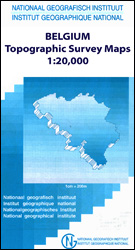
- Topographical survey of Belgium at 1:20,000 from Nationaal Geografisch Instituut / Institut Géographique National, the country’s national survey organization. Each 20K map covers one quarter of the corresponding 1:50,000 map (with adjustments in the border and coastal areas). The maps provide all the information expected of topographic mapping... Read more
Stanfords
United Kingdom
United Kingdom
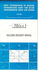
- Villers devant Orval
- Topographical survey of Belgium at 1:20,000 from Nationaal Geografisch Instituut / Institut Géographique National, the country’s national survey organization. Each 20K map covers one quarter of the corresponding 1:50,000 map (with adjustments in the border and coastal areas). The maps provide all the information expected of topographic mapping... Read more

Stanfords
United Kingdom
United Kingdom
- World Map Placemat
- This is a fantastic colourful and resistant placemat by Little Wigwam, featuring a political world map. Kids will love it and have fun locating remote places or guessing capitals of the world. The Mercator projection map shows the continents in different bright colours, all countries and seas and oceans are named, as well as most capitals,... Read more
Stanfords
United Kingdom
United Kingdom
- Burg-Reuland - Gross-Bohlscheid
- Topographical survey of Belgium at 1:20,000 from Nationaal Geografisch Instituut / Institut Géographique National, the country’s national survey organization. Each 20K map covers one quarter of the corresponding 1:50,000 map (with adjustments in the border and coastal areas). The maps provide all the information expected of topographic mapping... Read more

Stanfords
United Kingdom
United Kingdom
- Kieldrecht- Doel
- Topographical survey of Belgium at 1:20,000 from Nationaal Geografisch Instituut / Institut Géographique National, the country’s national survey organization. Each 20K map covers one quarter of the corresponding 1:50,000 map (with adjustments in the border and coastal areas). The maps provide all the information expected of topographic mapping... Read more
Stanfords
United Kingdom
United Kingdom
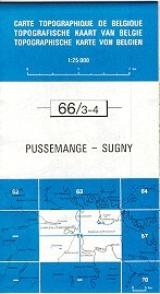
- Pussemange - Sugny
- Topographical survey of Belgium at 1:20,000 from Nationaal Geografisch Instituut / Institut Géographique National, the country’s national survey organization. Each 20K map covers one quarter of the corresponding 1:50,000 map (with adjustments in the border and coastal areas). The maps provide all the information expected of topographic mapping... Read more

Stanfords
United Kingdom
United Kingdom
- Seraing - Chaudfontaine
- Topographical survey of Belgium at 1:20,000 from Nationaal Geografisch Instituut / Institut Géographique National, the country’s national survey organization. Each 20K map covers one quarter of the corresponding 1:50,000 map (with adjustments in the border and coastal areas). The maps provide all the information expected of topographic mapping... Read more

Stanfords
United Kingdom
United Kingdom
- Monde Connu en 1688 par Jaugeon
- High quality reproduction from the IGN of a beautifully engraved map of the world prepared in 1688 by Jacques Jaugeon, French scholar and royal typographer during the reign of King Louis XIV. The map presents the world in two hemispheres, surrounded by allegorical figures representing the constellations and definitions of geographical terms... Read more
Stanfords
United Kingdom
United Kingdom
- Mons - Givry
- Topographical survey of Belgium at 1:20,000 from Nationaal Geografisch Instituut / Institut Géographique National, the country’s national survey organization. Each 20K map covers one quarter of the corresponding 1:50,000 map (with adjustments in the border and coastal areas). The maps provide all the information expected of topographic mapping... Read more

Stanfords
United Kingdom
United Kingdom
- Geological Map of the World Wall Map
- This new edition (August 2014) reconsiders the 3rd edition of the Geological Map of the Word, published initially in 2010 at the scales of 1:25 000 000 (3 sheets) and 1:50 000 000 (1 sheet Geology, structure), both presently out of print.The layout of this new version, centered on the Atlantic, was redesigned in order to fit a single sheet,... Read more

Stanfords
United Kingdom
United Kingdom
- Odeigne - Bihain
- Topographical survey of Belgium at 1:20,000 from Nationaal Geografisch Instituut / Institut Géographique National, the country’s national survey organization. Each 20K map covers one quarter of the corresponding 1:50,000 map (with adjustments in the border and coastal areas). The maps provide all the information expected of topographic mapping... Read more

Stanfords
United Kingdom
United Kingdom
- World Global Mapping Magnetic Fridge Map
- One of our best-selling maps of the world is now available to stick on your fridge, or any other magnetic surface.At a scale of 1:100,000,000 this wonderful fridge magnet measures 25.5x41.5cm and is flexibly made to simply peel on and peel off whenever you wish to display it.Bright, colourful and informative, this quirky magnetic World map... Read more

Stanfords
United Kingdom
United Kingdom
- Vielsalm - Recht
- Topographical survey of Belgium at 1:20,000 from Nationaal Geografisch Instituut / Institut Géographique National, the country’s national survey organization. Each 20K map covers one quarter of the corresponding 1:50,000 map (with adjustments in the border and coastal areas). The maps provide all the information expected of topographic mapping... Read more
Stanfords
United Kingdom
United Kingdom
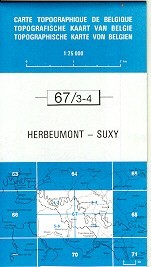
- Herbeumont - Suxy
- Topographical survey of Belgium at 1:20,000 from Nationaal Geografisch Instituut / Institut Géographique National, the country’s national survey organization. Each 20K map covers one quarter of the corresponding 1:50,000 map (with adjustments in the border and coastal areas). The maps provide all the information expected of topographic mapping... Read more