
GR65 Camino de Santiago
Description
- Name GR65 Camino de Santiago (GR65)
- Length of trail 800 km, 497 miles
- Length in days 32 days
- End of trail Santiago de Compostela
- Traildino grading MW, Moderate walk, backpacking trail
- Hut tour grading T1, Walk


GR65 Camino de Santiago, GR 65.3, GR 65.5
This path is better known as the Camino Francés, the main Way of St. Jacob from France over the Pyrenees to Santiago de Compostela. The GR65.5 is a trail in Catalunya: Camino de Tarragona. The GR65.3 is the Camino Aragonés.
Visit Traildino's overview page for the Way of Saint James / Camino de Santiago.
Select some tracks
☐GR 65.5, 116km
☐Viejo Camino de Santiago por el Valle de Hecho - Calzada del Summo Pyreneo, 51km
☐GR 65 Variante, 9.5km
☐GR 65.3.1 Camino Aranonés, 6.9km
☐6 Camino de Santiago, 12km
☐Camino de Levante, 76km
☐Baztango Donejakue bidea / Camino de Santiago de Baztán, 104km
☐Camino de Santiago de la Lana.Senderista, 411km
☐Camino Mozárabe. Almería-Granada, 198km
☐Camino de Santiago Vasco del Interior, 203km
☐Camino de Santiago Vasco del Interior, 95km
☐Camino de Santiago Vasco del Interior - Variante de Saiatz, 63km
☐Camino de Aníbal. Camino de Santiago del Sureste, 23km
☐Camino del Salvador - Bifurcación por pueblo de Pajares, 5.4km
☐Camino Francés, alternative route, 16km
☐Camino de Santiago de la Lana.Senderista(Var.Sigüenza), 40km
☐Jakobsweg via Baltica, Schleswig-Holstein Ost - Aternative Possehlbrücke, 2.7km
☐Camino Vadiniense, 151km
☐Ostbayerischer Jakobsweg: nördliche Variante (Eschlkam > Donauwörth), 37km
☐Voie du Piémont, Saint-Bertrand-de-Comminges - Bagnères-de-Bigorre, 3.7km
☐Camino de Santiago de Gran Canaria, 27km
☐Camino Mendocino, 97km
☐GR 65.5.1 Ulldemolins - Venda de la Serra la Llena, 7.3km
☐Camino Manchego de Santiago, 90km
☐Camino de Santiago del Sur, 177km
☐Camino Mozárabe desde Málaga, 153km
☐Camino del Maestrazgo-Bajo Aragón, 241km
☐Camino Mozárabe por Trujillo, 203km
☐Jakobsweg Bad Münstereifel - Trier - Perl (Alternative)
☐Svätojakubská Cesta, 120km
☐Camino de Santiago Complutense, 128km
☐Jakobsweg Neresheim - Ulm, 68km
☐Šv. Jokūbo kelias (Lietuva), 82km
☐Camino de Santiago en Guadalajara, 92km
☐Chemin de Saint-Jacques-de-Compostelle, 1.2km
☐Via Regia (GŚA), 75km
☐Jakobsweg Silberberg (Variante Kirchberg–Hirschfeld), 20km
☐Voie de la Pointe Saint-Mathieu
☐Jakobsweg an der Frankenstraße, Variante Karswald, 9.9km
☐Tübinger Jakobusweg, 11km
☐Camino de Santiago, 1.2km
☐Camino Mozárabe. Variante a Tocón de Quéntar., 1.5km
☐Chemin de Lorient, 15km
☐camino de Santiago, 0.7km
☐Svätojakubská cesta na Slovensku: Úsek Rajka (HU) – Bratislava
☐Camiño A Orixe, 110km
☐El Camino de Santiago entre Volcanes, 35km
☐Via son Giachen, 3.8km
☐Jakobs-Pilgerweg Bielefeld-Wesel, 195km
☐Jakobsweg Saar, Strecke Altheim – Kleinblittersdorf – Saargemünd – Hérapel, 60km
☐Jakobsweg - Via Jutlandica - Schleswig-Holstein (Jakobsweg Dithmarschen), westliche Route, Abstecher Franziskusweg, 4.8km
☐Jakobsweg – Via Regia
☐Jakobsweg Via Scandinavica, Schleswig-Holstein - Aternative Possehlbrücke, 3.7km
☐Jakobs-Pilgerweg Eisenach - Marburg, 177km
☐▽Cette relation est une section de la Voie de Tours gérée par les associations jacquaires, ne pas modifier son tracé sur la base de la Voie de Tours de la FFRP
☐.Cette relation est une section de la Voie de Tours gérée par les associations jacquaires, ne pas modifier son tracé sur la base de la Voie de Tours de la FFRP, 41km
☐.Cette relation est une section de la Voie de Tours gérée par les associations jacquaires, ne pas modifier son tracé sur la base de la Voie de Tours de la FFRP, 19km
☐.Cette relation est une section de la Voie de Tours gérée par les associations jacquaires, ne pas modifier son tracé sur la base de la Voie de Tours de la FFRP, 15km
☐.Cette relation est une section de la Voie de Tours gérée par les associations jacquaires, ne pas modifier son tracé sur la base de la Voie de Tours de la FFRP, 17km
☐.Cette relation est une section de la Voie de Tours gérée par des associations jacquaires, ne pas modifier son tracé sur la base de la Voie de Tours de la FFRP, 19km
☐.Cette relation est une section de la Voie de Tours gérée par des associations jacquaires, ne pas modifier son tracé sur la base de la Voie de Tours de la FFRP, 18km
☐.Cette relation est une section de la Voie de Tours gérée par des associations jacquaires, ne pas modifier son tracé sur la base de la Voie de Tours de la FFRP, 39km
☐Cette relation est une section commune aux Voies de Tours gérées par les associations jacquaires et par la FFRP, 76km
☐Cette relation est une section de la Voie de Tours gérée par les associations jacquaires, ne pas modifier son tracé sur la base de la Voie de Tours de la FFRP, 136km
☐▽Cette relation est une section de la Voie de Tours gérée par les associations jacquaires, ne pas modifier son tracé sur la base de la Voie de Tours de la FFRP
☐Jakobsweg Wolfsthal-Schwechat, 55km
☐Südösterreichischer Jakobsweg, 16km
☐Via son Giachen, 17km
☐Via son Giachen, 14km
☐Via son Giachen, 13km
☐Via son Giachen, 11km
☐Via son Giachen, 16km
☐Via son Giachen, 7.3km
☐Via son Giachen, 16km
☐Via son Giachen, 12km
☐Via son Giachen, 3.5km
☐Via son Giachen, 4.9km
☐Via son Giachen, 10km
☐Via son Giachen, 21km
☐Via son Giachen, 15km
☐Via son Giachen, 12km
☐Camino Benedictus, Tihany-Lébény, 163km
☐ViaJacobi, 26km
☐ViaJacobi, 24km
☐ViaJacobi, 28km
☐ViaJacobi, 17km
☐ViaJacobi, 19km
☐ViaJacobi, 30km
☐ViaJacobi, 17km
☐ViaJacobi, 23km
☐ViaJacobi, 30km
☐ViaJacobi, 17km
☐ViaJacobi, 23km
☐ViaJacobi, 21km
☐ViaJacobi, 20km
☐ViaJacobi, 27km
☐ViaJacobi, 15km
☐ViaJacobi, 29km
☐ViaJacobi, 31km
☐ViaJacobi, 27km
☐ViaJacobi, 17km
☐ViaJacobi, 9.2km
☐ViaJacobi, 15km
☐ViaJacobi, 27km
☐ViaJacobi, 30km
☐ViaJacobi, 19km
☐ViaJacobi, 14km
☐ViaJacobi, 16km
☐ViaJacobi, 23km
☐ViaJacobi, 29km
☐ViaJacobi, 21km
☐ViaJacobi - Fribourg (Villars-sur-Glâne)–Payerne, 20km
☐ViaJacobi, 17km
☐Zittauer Jakobsweg Görlitz - Prag, 196km
☐Svētā Jēkaba ceļš (Rīga-Skaistkalne) 1 etaps: Rīga – Salaspils, 23km
☐Svētā Jēkaba ceļš (Rīga-Skaistkalne) 2 etaps: Salaspils – Ogre, 26km
☐Svētā Jēkaba ceļš (Rīga-Skaistkalne) 3 etaps: Ogre – Ķegums, 21km
☐Svētā Jēkaba ceļš (Rīga-Skaistkalne) 4 etaps: Ķegums – Vecumnieki, 23km
☐Svētā Jēkaba ceļš (Rīga-Skaistkalne) 5 etaps: Vecumnieki – Brukna, 26km
☐Svētā Jēkaba ceļš (Rīga-Skaistkalne) 6 etaps: Brukna – Skaistkalne, 28km
☐Jakobsweg Vorarlberg, 22km
Map


Links
Facts
Reports
Guides and maps
Lodging
Organisations
Tour operators
GPS
Other
Books

Stanfords
United Kingdom
2021
United Kingdom
2021
- Camino de Santiago: The ancient Way of Saint James pilgrimage route from the French Pyrenees to Santiago de Compostela
- El Camino de Santiago de Compostela, the ancient Christian pilgrimage route has been travelled for over a thousand years to the Cathedral of Santiago de Compostela, where, legend has it, the bones of St James are buried. This guide follows the most popular route, starting at St Jean-Pied-de-Port in south-west France and heading all the way... Read more

Stanfords
United Kingdom
United Kingdom
- DK Eyewitness Spain
- Discover Spain - a compelling country filled with must-see sightsWhether you want to explore Granada`s spectacular Alhambra palace, watch swirling flamenco dancers in Seville or walk through lush countryside on the epic Camino de Santiago, your DK Eyewitness travel guide makes sure you experience all that Spain has to offer.From the golden... Read more

Stanfords
United Kingdom
2019
United Kingdom
2019
- Sentiers de Saint-Jacques-de-Compostelle - Via Le Puy - Geneve - Le Puy GR65
- Chemins de St-Jacques: Geneva - Le Puy-en-Velay, FFRP topoguide Ref. No. 650, covering a 360km section of the GR65 along one of the routes of the Way of St. James across France. Current edition of this title was published in March 2016.ABOUT THE FFRP (Fédération française de la randonnée pédestre) TOPOGUIDES: published in a handy A5 paperback... Read more
Stanfords
United Kingdom
2018
United Kingdom
2018
- Sentiers de St-Jacques via le Puy - Le Puy to Figeac GR65
- Chemins de St-Jacques: Le Puy - Figeac, FFRP topoguide Ref. no. 651, covering a 252km section of the Way of St. James across the Massif Central from Le Puy-en-Velay to Figeac along the GR 65. Current edition of this title was published in August 2014.ABOUT THE FFRP (Fédération française de la randonnée pédestre) TOPOGUIDES: published in a handy... Read more

Stanfords
United Kingdom
2016
United Kingdom
2016
- St-Jacques-de-Compostelle - Puy-en-Velay to Moissac GR65-1 IGN 89020
- Chemin de St-Jacques - the Way of St James in France along the GR65 between Le Puy-en-Velay and Moissac presented at 1:100,000 on a double-sided, waterproof and tear-resistant map from IGN with cartography from their highly popular TOP100 series. The route is prominently highlighted on contoured mapping and annotated with hiking distances.... Read more

Stanfords
United Kingdom
2017
United Kingdom
2017
- Sentiers de St- Jacques via le Puy - Moissac to Roncevaux GR65
- Continuation and end of the Puy road, through Quercy, Béarn and Basque Country. More than 15 days of hiking.Chemins de St- Jacques: Moissac - Roncevaux (Roncesvalles), FFRP topoguide Ref. no. 653, covering the last, 345-km long section of the Way of St. James in France along the GR65 between Le Puy-en-Velay to the Spanish border. Current... Read more

Stanfords
United Kingdom
2016
United Kingdom
2016
- St-Jacques-de-Compostelle - Moissac to Roncevaux / Roncesvalles GR65-2 IGN 89021
- Chemin de St-Jacques - the Way of St James in France along the GR65 between Moissac and Roncevaux/Roncesvalles in the Spanish Pyrenees presented at 1:100,000 on a double-sided, waterproof and tear-resistant map from IGN with cartography from their highly popular TOP100 series. The route is prominently highlighted on contoured mapping and... Read more


The Book Depository
United Kingdom
2019
United Kingdom
2019
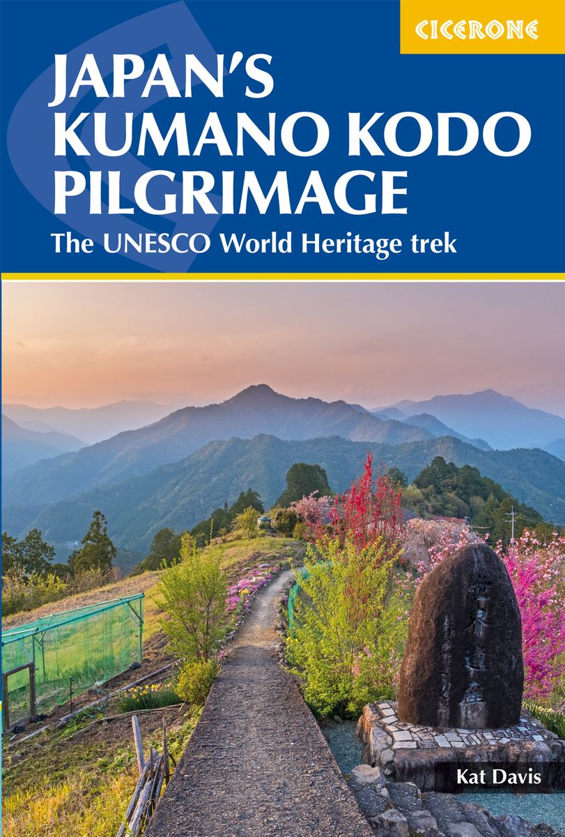
- Japan's Kumano Kodo Pilgrimage
- The UNESCO World Heritage trek Read more
- Also available from:
- De Zwerver, Netherlands
De Zwerver
Netherlands
2019
Netherlands
2019
- Wandelgids Japan's Kumano Kodo Pilgrimage | Cicerone
- Guidebook to walking Japan's Kumano Kodo, a network of ancient pilgrimage trails on the Kii Peninsula, south of Osaka. Covering the Nakahechi, Kohechi and Iseji trails, as well as Koyasan and the Choishimichi route, the guide has all the practical information needed, along with notes on the routes' rich history and culture. Read more

The Book Depository
United Kingdom
2022
United Kingdom
2022
- Camino De Santiago
- SantiagoCamino Frances: St. Jean - Santiago - Finisterre Read more

The Book Depository
United Kingdom
2022
United Kingdom
2022
- Camino de Santiago - Via Podiensis
- Le Puy to the Pyrenees on the GR65 Read more
- Also available from:
- De Zwerver, Netherlands

De Zwerver
Netherlands
2022
Netherlands
2022
- Wandelgids Camino de Santiago - Via Podiensis GR65 | Cicerone
- Le Puy to the Pyrenees on the GR65 Read more

The Book Depository
United Kingdom
United Kingdom
- Guided by Shadows
- A Westward Walk on Spain's Camino de Santiago Read more

The Book Depository
United Kingdom
United Kingdom
- There's something going on!
- Walking the Camino de Santiago Read more

The Book Depository
United Kingdom
2022
United Kingdom
2022
- A Pilgrim's Guide to Sarria - Santiago
- The Final 7 Stages of the Camino De Santiago Frances Read more

The Book Depository
United Kingdom
United Kingdom
- A Walk in Spain
- Spiritual Awakening on the Camino de Santiago Read more
Maps

Stanfords
United Kingdom
2010
United Kingdom
2010
- Camino de Santiago 50K CNIG Topo 11-Map Box Set
- The whole of Way of St James to Santiago de Compostela in a set of 11 maps: 10 double-sided topographic maps at 1:50,000 plus an overview map of northern Spain, published by the Spanish civilian survey organization.Each 1:50,000 map is double-sided and has four 57 x 35cm panels with full topographic mapping of the area through which the route... Read more

Stanfords
United Kingdom
United Kingdom
- Lugo and Environs CNIG Map
- Lugo and its environs on a double-sided map combining a street plan with topographic mapping at 1:50,000 from the Instituto Geográfico Nacional – Centro Nacional de Información Geograficá, the country’s civilian survey organization.On one side is a street plan of the city showing the course along its streets of the Camino de Santiago – the Way... Read more

Stanfords
United Kingdom
United Kingdom
- Massif de la Vanoise IGN Wall Map
- Massif de la Vanoise presented on an encapsulated waterproof wall map, size 100 x 132cm (39.5” x 52” approx), with cartography of IGN’s excellent TOP25 series reduced slightly to 1:28,000. The map combines sections of TOP25 maps 3532ET, 3532OT, 3534OT, 3633ET and 3634OT to extend from Mâcot-la-Plagne and Aiguille Rouge in the north to Lac du... Read more

Stanfords
United Kingdom
2017
United Kingdom
2017
- Le Chemin du Piemont Pyreneen - vers Saint-Jacques-de-Compostell
- Le Chemin du Piémont Pyrénéen, FFRP topoguide, Ref. No. 780, covering the GR78 - the Way of St. James along the northern side of the Pyrenees from Carcassonne to Roncesvalles on the Spanish side, with an alternative variant to cross the mountains along the Col du Somport. Current edition of this title was published in May 2017.The route, the... Read more

Stanfords
United Kingdom
United Kingdom
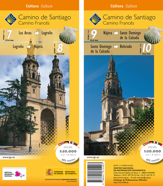
- Camino de Santiago: Stages 7/8/9/10, Los Arcos/Belorado 50K CNIG Map
- Camino de Santiago: Stages 7/8/9/10, Los Arcos/Belorado, in a series of double-sided topographic maps at 1:50,000 from the Spanish civilian survey organization, overprinted with the route and sights, plus information of accommodation and other facilities, route profiles, etc.Each 1:50,000 map is double-sided and has four 57 x 35cm panels with... Read more
- Also available from:
- De Zwerver, Netherlands
De Zwerver
Netherlands
Netherlands
- Wandelkaart 7-10 Camino Santiago de Compostella Los Arcos - Belorado | CNIG - Instituto Geográfico Nacional
- Camino de Santiago: Stages 7/8/9/10, Los Arcos/Belorado, in a series of double-sided topographic maps at 1:50,000 from the Spanish civilian survey organization, overprinted with the route and sights, plus information of accommodation and other facilities, route profiles, etc.Each 1:50,000 map is double-sided and has four 57 x 35cm panels with... Read more
Stanfords
United Kingdom
United Kingdom
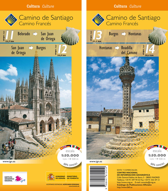
- Camino de Santiago: Stages 11/12/13/14, Belorado/Boadilla del Camino 50K CNIG Map
- Camino de Santiago: Stages 11/12/13/14, Belorado/Boadilla del Camino, in a series of double-sided topographic maps at 1:50,000 from the Spanish civilian survey organization, overprinted with the route and sights, plus information of accommodation and other facilities, route profiles, etc.Each 1:50,000 map is double-sided and has four 57 x 35cm... Read more
- Also available from:
- De Zwerver, Netherlands
De Zwerver
Netherlands
Netherlands
- Wandelkaart 11-14 Camino Santiago de Compostella Belorado - Boadilla | CNIG - Instituto Geográfico Nacional
- Camino de Santiago: Stages 11/12/13/14, Belorado/Boadilla del Camino, in a series of double-sided topographic maps at 1:50,000 from the Spanish civilian survey organization, overprinted with the route and sights, plus information of accommodation and other facilities, route profiles, etc.Each 1:50,000 map is double-sided and has four 57 x 35cm... Read more

De Zwerver
Netherlands
2020
Netherlands
2020
- Wandelatlas - Pelgrimsroute (kaart) 161 Chemins de Compostelle GR65 | Michelin
- Véritable petit atlas détaillant chaque étape avec indications précises concernant les villes de départ et d'arrivée ainsi que pour les localités traversées (auberges, refuges, restaurants, pharmacies, gare, épiceries, Km parcourus, Km restants....).Ce petit atlas suit le chemin du... Read more
Stanfords
United Kingdom
United Kingdom
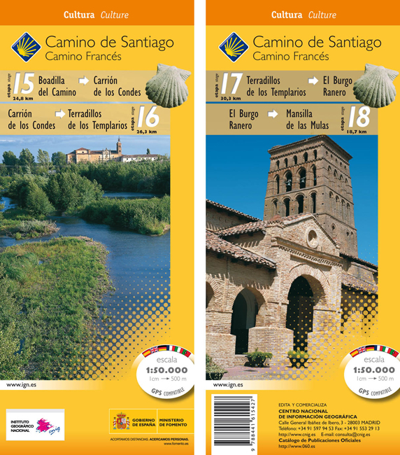
- Camino de Santiago: Stages 15/16/17/18, Boadilla del Camino/Mansilla de las Mulas 50K CNIG Map
- Camino de Santiago: Stages 15/16/17/18, Boadilla del Camino/Mansilla de las Mulas, in a series of double-sided topographic maps at 1:50,000 from the Spanish civilian survey organization, overprinted with the route and sights, plus information of accommodation and other facilities, route profiles, etc.Each 1:50,000 map is double-sided and has... Read more
- Also available from:
- De Zwerver, Netherlands
De Zwerver
Netherlands
Netherlands
- Wandelkaart 15-18 Camino Santiago de Compostella Boadilla - Mansilla | CNIG - Instituto Geográfico Nacional
- Camino de Santiago: Stages 15/16/17/18, Boadilla del Camino/Mansilla de las Mulas, in a series of double-sided topographic maps at 1:50,000 from the Spanish civilian survey organization, overprinted with the route and sights, plus information of accommodation and other facilities, route profiles, etc.Each 1:50,000 map is double-sided and has... Read more

Stanfords
United Kingdom
2013
United Kingdom
2013
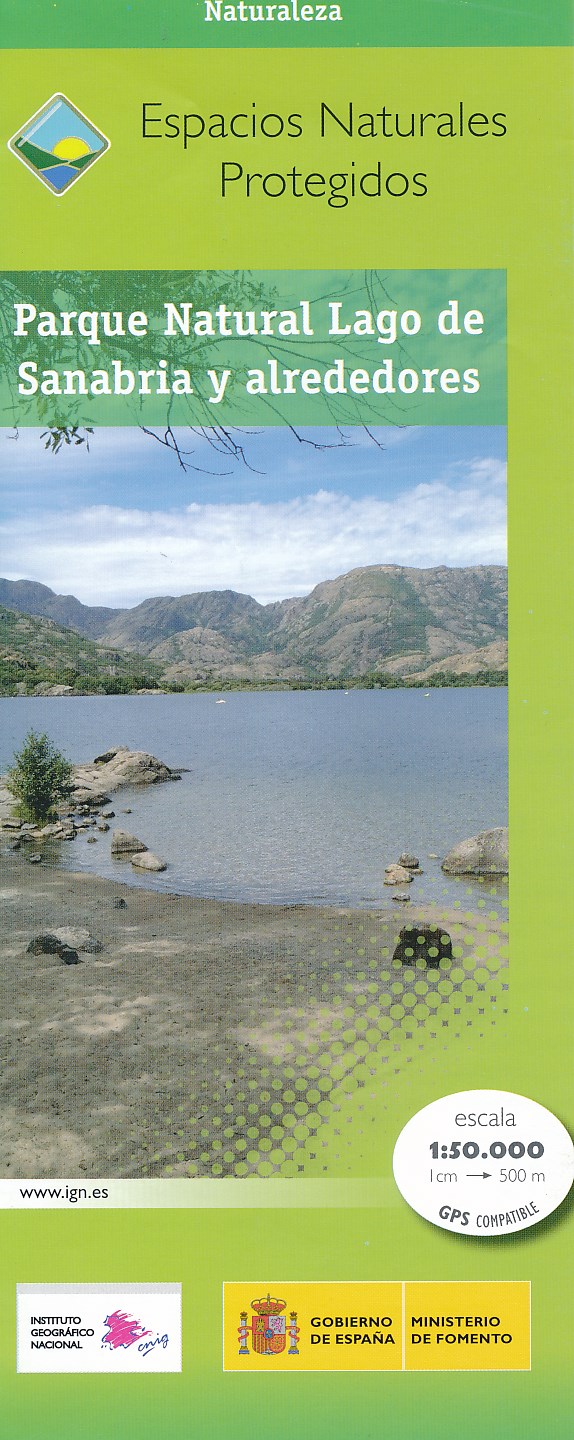
- Sanabria Lake and Surroundings NP CNIG Map
- Lago de Sanabria Natural Park and the surrounding area of north-eastern Spain near the Portuguese border on a detailed, GPS compatible topographic map at 1:50,000 from the country’s civilian survey organization, highlighting waymarked hiking trails, tourist accommodation and places of interest, etc.The map has the cartography of Spain’s... Read more
- Also available from:
- De Zwerver, Netherlands
De Zwerver
Netherlands
2013
Netherlands
2013
- Wandelkaart Parques Nacionales Parque Naturel Lago de Sanabria y alrededores | CNIG - Instituto Geográfico Nacional
- Lago de Sanabria Natural Park and the surrounding area of north-eastern Spain near the Portuguese border on a detailed, GPS compatible topographic map at 1:50,000 from the country Read more

De Zwerver
Netherlands
2020
Netherlands
2020
- Wandelatlas - Pelgrimsroute (kaart) 160 Camino de Santiago | Michelin
- Parcourez le Chemin Français (Camino Francés) avec ce petit atlas de poche Michelin. L'outil idéal pour mieux s'y retrouver lors de la préparation du voyage de randonnée sur ce sentier historique qui part de Saint-Jean-Pied-de-Port, dans le Pays basque français, et qui traverse tout le nord de l'Espagne... Read more

Stanfords
United Kingdom
United Kingdom
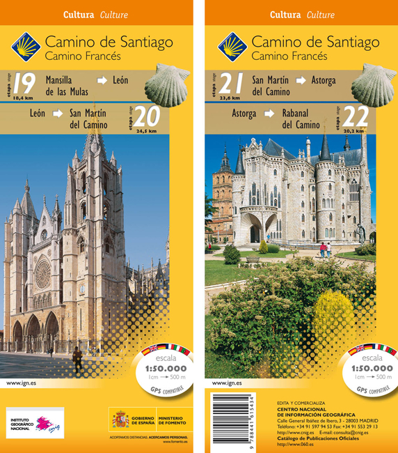
- Camino de Santiago: Stages 19/20/21/22, Mansilla de las Mulas/Rabanal del Camino 50K CNIG Map
- Camino de Santiago: Stages 19/20/21/22, Mansilla de las Mulas/Rabanal del Camino, in a series of double-sided topographic maps at 1:50,000 from the Spanish civilian survey organization, overprinted with the route and sights, plus information of accommodation and other facilities, route profiles, etc.Each 1:50,000 map is double-sided and has... Read more
- Also available from:
- De Zwerver, Netherlands
De Zwerver
Netherlands
Netherlands
- Wandelkaart 19-22 Camino Santiago de Compostella Mansilla - Rabanal | CNIG - Instituto Geográfico Nacional
- Camino de Santiago: Stages 19/20/21/22, Mansilla de las Mulas/Rabanal del Camino, in a series of double-sided topographic maps at 1:50,000 from the Spanish civilian survey organization, overprinted with the route and sights, plus information of accommodation and other facilities, route profiles, etc.Each 1:50,000 map is double-sided and has... Read more
De Zwerver
Netherlands
Netherlands
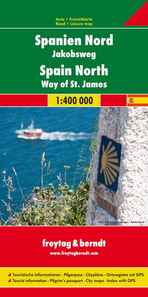
- Wegenkaart - landkaart Spanje Noord - Camino de Santiago | Freytag & Berndt
- Spanien - Jakobsweg, Autokarte 1:400.000 ab 10.9 EURO Touristische Informationen, Pilgerpass, Citypläne, Ortsregister mit GPS Freytag & Berndt Autokarte Read more

Stanfords
United Kingdom
United Kingdom
- Camino de Santiago: Stages 23/24/25/26, Rabanal del Camino/Triacastela 50K CNIG Map
- Camino de Santiago: Stages 23/24/25/26, Rabanal del Camino/Triacastela, in a series of double-sided topographic maps at 1:50,000 from the Spanish civilian survey organization, overprinted with the route and sights, plus information of accommodation and other facilities, route profiles, etc.Each 1:50,000 map is double-sided and has four 57 x... Read more
- Also available from:
- De Zwerver, Netherlands

De Zwerver
Netherlands
Netherlands
- Wandelkaart 23-26 Camino Santiago de Compostella Rabanal - Triacastela | CNIG - Instituto Geográfico Nacional
- Camino de Santiago: Stages 23/24/25/26, Rabanal del Camino/Triacastela, in a series of double-sided topographic maps at 1:50,000 from the Spanish civilian survey organization, overprinted with the route and sights, plus information of accommodation and other facilities, route profiles, etc.Each 1:50,000 map is double-sided and has four 57 x... Read more

Stanfords
United Kingdom
United Kingdom
- Caminos de Santiago / Ways of St. James on the Iberian Peninsula CNIG Overview Map
- All roads leading to Santiago de Compostela in the Iberian Peninsula are represented on this Caminos de Santiago / The Way of St. James Map. Routes highlighted on a physical map of the Iberian Peninsula at 1:1,250,000 from IGN/CNIG, Spain civilian topographic survey organization. The base map with altitude colouring and relief shading provides... Read more
- Also available from:
- De Zwerver, Netherlands

De Zwerver
Netherlands
Netherlands
- Pelgrimsroute (kaart) - Wandelkaart Camino de Santiago in Spanje | CNIG - Instituto Geográfico Nacional
- All roads leading to Santiago de Compostela in the Iberian Peninsula are represented on this Caminos de Santiago / The Way of St. James Map. Routes highlighted on a physical map of the Iberian Peninsula at 1:1,250,000 from IGN/CNIG, Spain civilian topographic survey organization. The base map with altitude colouring and relief shading provides... Read more
Stanfords
United Kingdom
United Kingdom
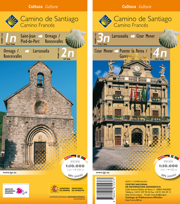
- Camino de Santiago: Stages 1n/2n/3n/4n, Saint-Jean-Pied-de-Port/Puente la Reina 50K CNIG Map
- The Way of St James: Stages 1n/2n/3n/4n, Saint-Jean-Pied-de-Port/Puente la Reina, in a series of double-sided topographic maps at 1:50,000 from the Spanish civilian survey organization, overprinted with the route and sights, plus information of accommodation and other facilities, route profiles, etc.Each 1:50,000 map is double-sided and has... Read more
- Also available from:
- De Zwerver, Netherlands
De Zwerver
Netherlands
Netherlands
- Wandelkaart 1n-4n Camino Santiago de Compostella St-Jean - Puente Reina | CNIG - Instituto Geográfico Nacional
- The Way of St James: Stages 1n/2n/3n/4n, Saint-Jean-Pied-de-Port/Puente la Reina, in a series of double-sided topographic maps at 1:50,000 from the Spanish civilian survey organization, overprinted with the route and sights, plus information of accommodation and other facilities, route profiles, etc.Each 1:50,000 map is double-sided and has... Read more