
Stanfords
United Kingdom
- Singapore SUPERCEDED
- This comprehensive new edition map covers Singapore Island to a scale of 1:55,000 and Sentosa Island to a scale of 1:25,000. City Plans feature Singapore City and Central District. Read more

Stanfords
United Kingdom
- Singapore Periplus Travel Map
- Singapore on a double-sided map by Periplus, providing road mapping of the Singapore Island and Sentosa Island, a street plan of Singapore City with a more detailed enlargement of its Central District, and a diagram of the MRT and LRT transport system.On one side is the whole of the Singapore Island, presented at 1:55,000. Road network... Read more
Stanfords
United Kingdom
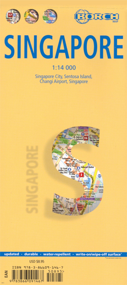
- Singapore Borch
- Laminated and waterproof map for visitors to Singapore from Borch, highlighting top 30 sights and combining a street plan of Singapore city’s central districts with a road map of the Singapore Island, plus maps of Sentosa Island, Changi Airport and public transport network.On one side is a street plan at 1:14,000 of Singapore City’s central... Read more

Stanfords
United Kingdom
- Singapore & Malay Peninsula ITMB
- Singapore City on a clear, indexed street plan at 1:10,000 with from ITMB, highlighting numerous places of interest and tourist facilities, plus the Singapore Island shown at 1:100,000 with its road and rail networks.The street plan covers the city’s central districts as indicated in our area coverage image, including the Financial District,... Read more
De Zwerver
Netherlands
De Zwerver
Netherlands