Aragón
Description
Map

Trails in this region
- GR1 Sendero Histórico, Senda TransversalGPX
- GR10 Senderos de la MielGPX
- GR11 Sendero PirenaicoGPX
- GR15 Sendero PrepirenaicoGPX
- GR16 Sendero del SerrabloGPX
- GR17 Sendero MarianoGPX
- GR18 Senderos de la RibagorzaGPX
- GR19 Senderos de SobrabeGPX
- GR23 Senderos por la LiteraGPX
- GR24 Senderos de Calatayud, Darroca y GallocantaGPX
- GR260 Vuelta al Moncayo-Calcenada
- GR45 Sendero del SomontanoGPX
- GR65 Camino de SantiagoGPX
- GR8 Puertos de Beceite - JavalambreGPX
- GR90 Tierras del MontcayoGPX
- GR95 Calzada Romana de Zaragoza a FranciaGPX
- GR99 Sendero del EbroGPX
Links
Facts
Reports
Guides and maps
Lodging
Organisations
Tour operators
GPS
Other
Books

Stanfords
United Kingdom
2018
United Kingdom
2018
- Val d`Azun à pied ST10
- Val d`Azun à pied, FFRP topo-guide Ref. No. ST10, with 18 day walks of varying length and difficulty in the French Pyrenees south-west of Argelès-Gazost, plus a tour which includes part of the GR10 long-distance footpaths. Each walk is presented on a separate colour extract from IGN’s topographic survey of France at 1:25,000 and/or 1:50,000,... Read more

Stanfords
United Kingdom
2020
United Kingdom
2020
- Les Abers - le Chemin de Phares GR34/GR34F
- Les Abers - le chemin de phares, FFRP topoguide Ref. no. 347, covering the coastal route in north-western Brittany between Morlaix, Brest, and le Fau, plus 4 walks on the Ile d`Ouessant. Current edition of this title was published in September 2017.Between Morlaix and Brest, where the sea has dug deep furrows in the land. More than 20 days of... Read more

Stanfords
United Kingdom
2011
United Kingdom
2011
- Le Parc de Millevaches en Limousin à pied FFRP Topo-guide No. PN17
- Le Parc de Millevaches en Limousin à pied, topo-guide Ref. No. PN017, with 18 day walks of varying length and difficulty, plus 270kms of hiking circuits in the department of Creuse. Current edition of this title was published in March 2011.To see the list of other FFRP guides with day walks please click on the series link.ABOUT THE FFRP... Read more
Stanfords
United Kingdom
2020
United Kingdom
2020
- Tour du Larzac, Templier - Hospitalier - Entre causses et vallées GR71C/GR71D
- Tour du Larzac - Templier et Hospitalier, FFRP topoguide Ref. No. 710, covering the 195kms of hiking circuits along the GR71C and GR71D south of Millau in the Causse du Larzac, plus 13 local day walks. Current edition of this title was published in December 2015.ABOUT THE FFRP (Fédération française de la randonnée pédestre) TOPOGUIDES:... Read more

Stanfords
United Kingdom
United Kingdom
- GR3: Les Monts du Forez FFRP Topo-guide No. 334
- Les Monts du Forez, FFRP topoguide Ref. No. 334, covering in all 259kms along the GR3 and its variant, with additional descriptions of 21 day walks in the region. Current edition of this title was published in April 2016.ABOUT THE FFRP (Fédération française de la randonnée pédestre) TOPOGUIDES: published in a handy A5 paperback format, the... Read more

Stanfords
United Kingdom
United Kingdom
- DK Eyewitness Spain
- Discover Spain - a compelling country filled with must-see sightsWhether you want to explore Granada`s spectacular Alhambra palace, watch swirling flamenco dancers in Seville or walk through lush countryside on the epic Camino de Santiago, your DK Eyewitness travel guide makes sure you experience all that Spain has to offer.From the golden... Read more

Stanfords
United Kingdom
2021
United Kingdom
2021
- Camino de Santiago: The ancient Way of Saint James pilgrimage route from the French Pyrenees to Santiago de Compostela
- El Camino de Santiago de Compostela, the ancient Christian pilgrimage route has been travelled for over a thousand years to the Cathedral of Santiago de Compostela, where, legend has it, the bones of St James are buried. This guide follows the most popular route, starting at St Jean-Pied-de-Port in south-west France and heading all the way... Read more

The Book Depository
United Kingdom
United Kingdom

- Also available from:
- De Zwerver, Netherlands
De Zwerver
Netherlands
2021
Netherlands
2021

- Also available from:
- De Zwerver, Netherlands


The Book Depository
United Kingdom
2023
United Kingdom
2023
- A Pilgrim's Guide to the Camino De Santiago
- Camino Frances St. Jean Pied De Port - Santiago Read more

The Book Depository
United Kingdom
United Kingdom
- The Road to Find Out
- A Modern Pilgrim and the Camino de Santiago Read more

The Book Depository
United Kingdom
United Kingdom
- Moon Camino de Santiago (Second Edition)
- Sacred Sites, Historic Villages, Local Food & Wine Read more
More books…

Maps

Stanfords
United Kingdom
United Kingdom
- Ordesa - Monte Perdido National Park Editorial Alpina 2-Map Set
- Ordesa and Monte Perdido National Park at 1:25,000 in a set of two GPS compatible recreational maps in an extensive and very popular series from Editorial Alpina, providing more detailed coverage of this popular hiking area.Contours are at 10m intervals, with relief shading and vegetation colouring. An overprint highlights waymarked PR hiking... Read more

Stanfords
United Kingdom
United Kingdom
- Ordesa and Monte Perdido National Park Editorial Alpina
- Ordesa and Monte Perdido National Park at 1:40,000 on a GPS compatible recreational map in an extensive and very popular series from Editorial Alpina, including a booklet with English language descriptions of several walks, climbs, etc.Contours are at 20m intervals, with relief shading and altitude colouring. An overprint highlights waymarked... Read more
- Also available from:
- The Book Depository, United Kingdom


The Book Depository
United Kingdom
United Kingdom
- Pyrenees Eastern
- Pyrénées Ouest map from the IGN at 1:200,000, with excellent presentation of the terrain through contours and vivid relief shading, plenty of names of topographic features, long-distance GR hiking routes, places of interest, etc. The map is designed to provide convenient coverage of the western and central part of the Pyrenees, extending across... Read more

The Book Depository
United Kingdom
2017
United Kingdom
2017
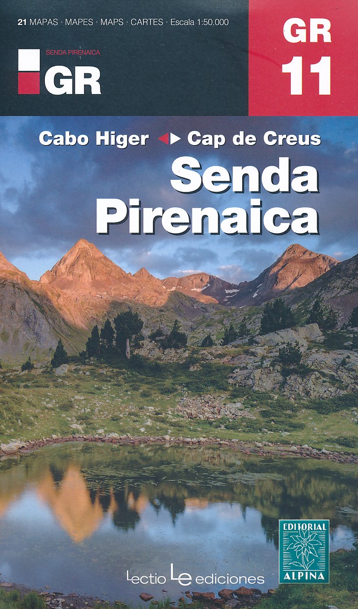
- Senda Pirenaica GR11 guide and map Cabo Higer - Cap de Creus 2017
- Set van 21 kaarten, schaal 1:50.000, met intekening van de GR11, de lange-afstandswandeling door de Spaanse Pyreneeën. Van kust tot kust, van Cabo Higuer (bij Irun) naar Cap de Creus (Costa Brava). Onderverdeeld in 43 trajecten. Met hoogteprofielen, gemiddelde looptijden, afstanden, locaties van berghutten, campings en hotels. Read more
- Also available from:
- De Zwerver, Netherlands
De Zwerver
Netherlands
2017
Netherlands
2017
- Wandelkaart Senda Pirenaica GR11 | Editorial Alpina
- Set van 21 kaarten, schaal 1:50.000, met intekening van de GR11, de lange-afstandswandeling door de Spaanse Pyreneeën. Van kust tot kust, van Cabo Higuer (bij Irun) naar Cap de Creus (Costa Brava). Onderverdeeld in 43 trajecten. Met hoogteprofielen, gemiddelde looptijden, afstanden, locaties van berghutten, campings en hotels. Read more

The Book Depository
United Kingdom
United Kingdom
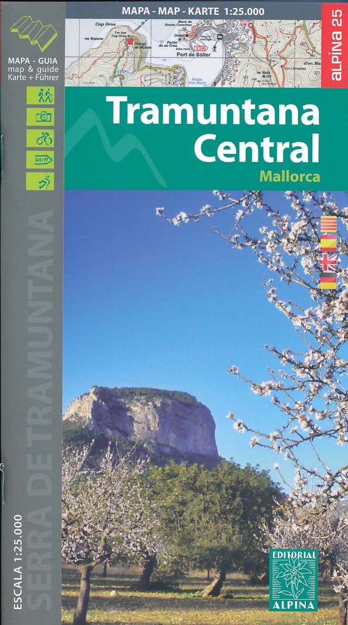
- Mallorca -Tramuntana Central GR11 Map and Hiking Guide
- Zeer gedetailleerde wandelkaart van een deel van de Tramuntana op Mallorca. Met ingetekende wandelroutes en andere informatie. uitstekende kaart. Met symbolen voor campings, hutten. Let op: deze uitgever is traag met het vernieuwen van kaarten; het kan zo maar zijn dat een bepaalde kaart gedurende langere tijd niet beschikbaar is. Majorca:... Read more
- Also available from:
- De Zwerver, Netherlands
De Zwerver
Netherlands
Netherlands
- Wandelkaart 67 Tramuntana Central - Mallorca | Editorial Alpina
- Zeer gedetailleerde wandelkaart van een deel van de Tramuntana op Mallorca. Met ingetekende wandelroutes en andere informatie. uitstekende kaart. Met symbolen voor campings, hutten. Let op: deze uitgever is traag met het vernieuwen van kaarten; het kan zo maar zijn dat een bepaalde kaart gedurende langere tijd niet beschikbaar is. Majorca:... Read more

The Book Depository
United Kingdom
2020
United Kingdom
2020
- Tour et travers�es du Massif des Bauges GR96/GRP
- Tours et Traversées du Massif des Bauges, FFRP topoguide Ref. no. 902, covering 500kms of routes in the French Alps between Annecy, Aix-les-Bains, Chambéry and Albertville. Current edition of this title was published in May 2015.ABOUT THE FFRP (Fédération française de la randonnée pédestre) TOPOGUIDES: published in a handy A5 paperback format,... Read more

The Book Depository
United Kingdom
United Kingdom
- Bearn - Aspe - Ossau - Pyrenees NP
- Uitstekende wandelkaart met veel toeristische informatie en bijzonder gedetailleerd. Wandelroute en hutten / campings zijn ingetekend, met hoogtelijnen. Andere dorpen op deze kaart: Etsaut - Col du Somport - Fabrèges - Col du Pourtalet - la Pierre Saint Martin - Arette - Arudy - Laruns - Arrens Marsous - Argelès Gazost (Frankrijk - Pyreneeen)... Read more
- Also available from:
- De Zwerver, Netherlands

De Zwerver
Netherlands
Netherlands
- Wandelkaart 03 Béarn - Bearn | Rando Editions
- Uitstekende wandelkaart met veel toeristische informatie en bijzonder gedetailleerd. Wandelroute en hutten / campings zijn ingetekend, met hoogtelijnen. Andere dorpen op deze kaart: Etsaut - Col du Somport - Fabrèges - Col du Pourtalet - la Pierre Saint Martin - Arette - Arudy - Laruns - Arrens Marsous - Argelès Gazost (Frankrijk - Pyreneeen)... Read more

The Book Depository
United Kingdom
United Kingdom
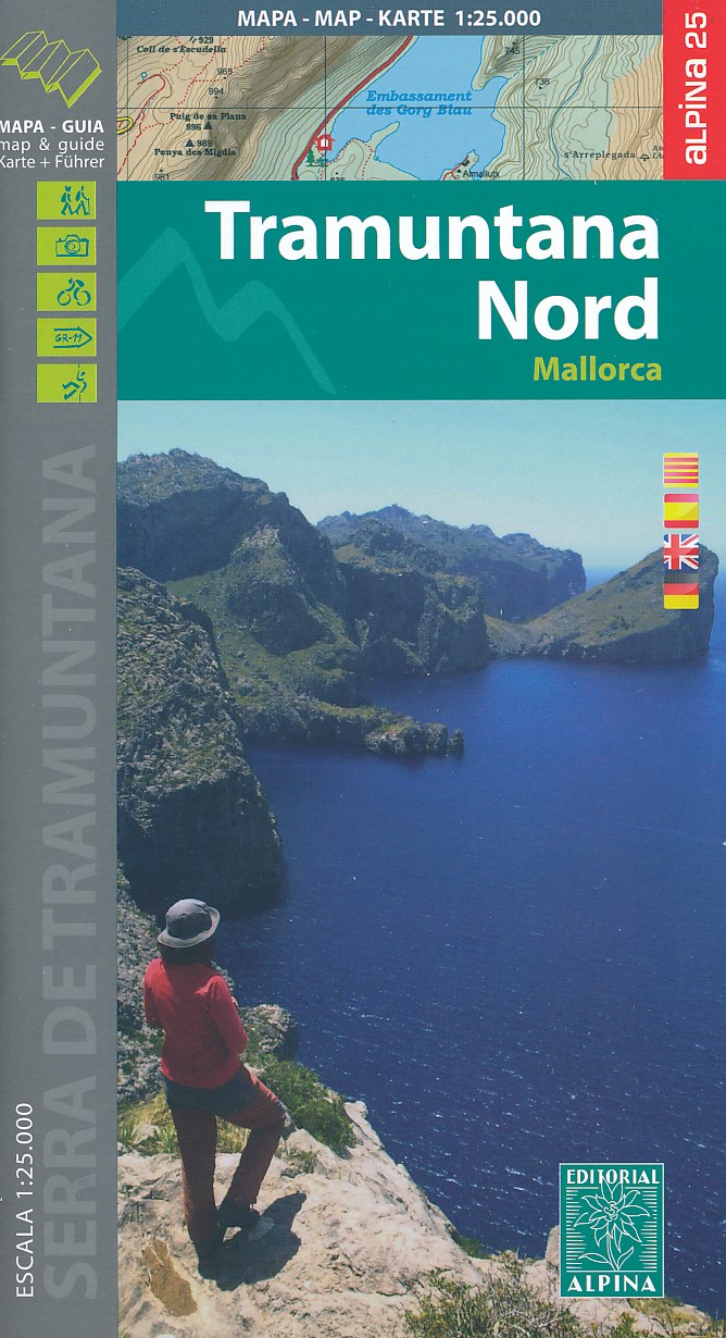
- Mallorca -Tramuntana Norte GR11 map and hiking guide
- Zeer gedetailleerde wandelkaart van een deel van de Tramuntana op Mallorca. Met ingetekende wandelroutes en andere informatie. uitstekende kaart. Met symbolen voor campings, hutten. Let op: deze uitgever is traag met het vernieuwen van kaarten; het kan zo maar zijn dat een bepaalde kaart gedurende langere tijd niet beschikbaar is. Majorca:... Read more
- Also available from:
- De Zwerver, Netherlands
De Zwerver
Netherlands
Netherlands
- Wandelkaart 68 Tramuntana Noord GR221 Mallorca | Editorial Alpina
- Zeer gedetailleerde wandelkaart van een deel van de Tramuntana op Mallorca. Met ingetekende wandelroutes en andere informatie. uitstekende kaart. Met symbolen voor campings, hutten. Let op: deze uitgever is traag met het vernieuwen van kaarten; het kan zo maar zijn dat een bepaalde kaart gedurende langere tijd niet beschikbaar is. Majorca:... Read more

The Book Depository
United Kingdom
2021
United Kingdom
2021
- Le long des ch�teaux de la Loire GR3/GR3B
- Le long des Châteaux de la Loire, FFRP topoguide Ref. No. 333, covering 552km route along the Loire from Bonny-sur-Loire across Orléans, Blois and Tours to Angers. Current edition of this title was published in May 2018.The Loire is world famous for its castles and gardens, now classified as World Heritage by UNESCO. The site of the Loire... Read more

- Also available from:
- De Zwerver, Netherlands


The Book Depository
United Kingdom
United Kingdom
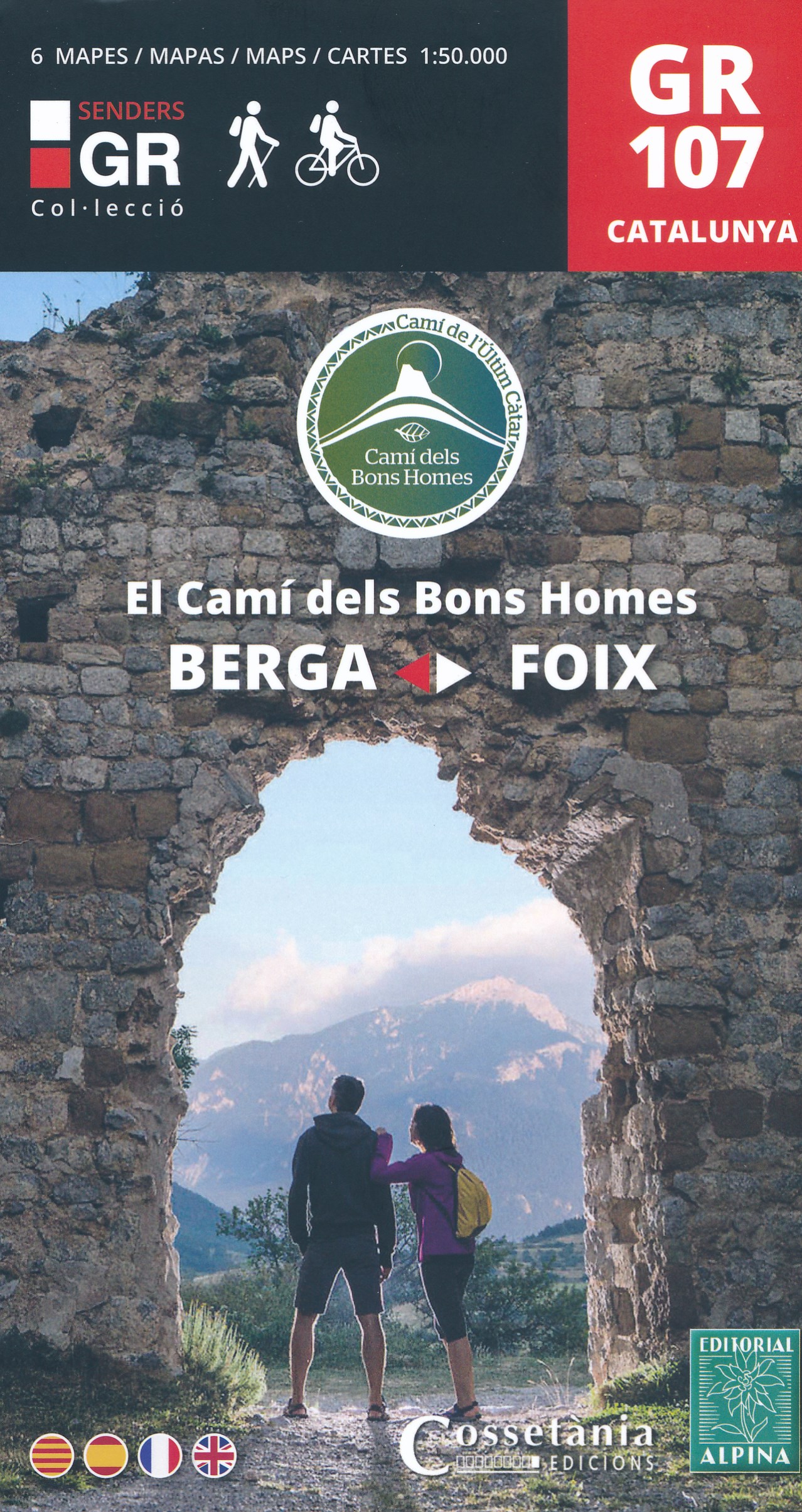
- El Cami dels Bons Homes / Trail of the Cathars GR107
- Uitstekende wandelkaart (in een set met 6 deelkaarten) van de GR107 die loopt van Foix in de Franse Pyreneeen tot Berga in de Catalaanse Pyreneeen. De kaarten zijn voldoende gedetailleerd om deze lange route te lopen. Met hoogteprofielen aan de zijkant, symbolen voor de noodzakelijke praktische informatie. Ruta a pie y en BTT, que recorre el... Read more
- Also available from:
- De Zwerver, Netherlands
De Zwerver
Netherlands
Netherlands
- Wandelkaart GR107 Berga - Foix , El Cami dels Bons Homes | Editorial Alpina
- Uitstekende wandelkaart (in een set met 6 deelkaarten) van de GR107 die loopt van Foix in de Franse Pyreneeen tot Berga in de Catalaanse Pyreneeen. De kaarten zijn voldoende gedetailleerd om deze lange route te lopen. Met hoogteprofielen aan de zijkant, symbolen voor de noodzakelijke praktische informatie. Ruta a pie y en BTT, que recorre el... Read more

The Book Depository
United Kingdom
United Kingdom
- Haut-Jura / Alpes du Nord
- Pyrénées Ouest map from the IGN at 1:200,000, with excellent presentation of the terrain through contours and vivid relief shading, plenty of names of topographic features, long-distance GR hiking routes, places of interest, etc. The map is designed to provide convenient coverage of the western and central part of the Pyrenees, extending across... Read more

- Also available from:
- De Zwerver, Netherlands


Stanfords
United Kingdom
United Kingdom
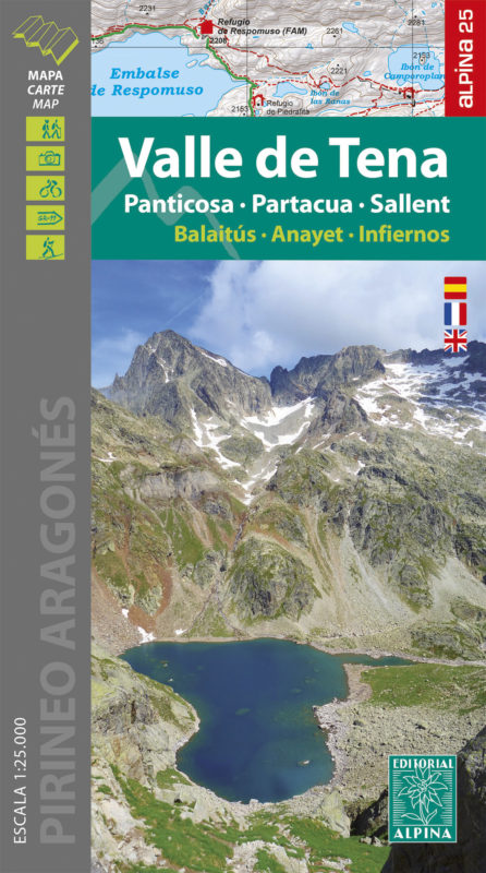
- Valle de Tena - Panticosa - Partacua - Sallent Editorial Alpina
- Valle de Tena in the central part of the Spanish Pyrenees on a contoured and GPS compatible map at 1:25,000 from Editorial Alpina, with coverage including Panticosa, Sallent de Gállego, Sierra de Partacua, Sierra de Tendeñera, etc. Accompanying booklet includes contact details for campsites, refuges, etc.Topography is presented by contours at... Read more
- Also available from:
- The Book Depository, United Kingdom
- De Zwerver, Netherlands