
Wales
Description
Map

Trails in this state
- All Wales Coast PathGPX
- Beacons WayGPX
- Cambrian Way
- Clwydian WayGPX
- Coed Morgannwg Way
- Dyfi Valley Way
- Glamorgan Ridgeway
- Glyndŵr's WayGPX
- Isle of Anglesey Coastal PathGPX
- Llŷn Coastal PathGPX
- North Wales PathGPX
- Offa's Dyke PathGPX
- Pembrokeshire Coast PathGPX
- Severn WayGPX
- Sirhowy Valley Walk
- Usk Valley WalkGPX
- Wye Valley WalkGPX
Links
Facts
Reports
Guides and maps
Lodging
Organisations
Tour operators
GPS
Other
Books

Stanfords
United Kingdom
United Kingdom
- Walks for All Ages in North East Wales: 20 Short Walks for All the Family
- 20 Short Walks for All the Family Read more

Stanfords
United Kingdom
2019
United Kingdom
2019
- Snowdonia & North Wales: AA 50 Walks
- Walking is one of Britain`s favourite leisure activities, and AA 50 Walks in Snowdonia & North Wales features a variety of mapped walks of two to ten miles, to suit all abilities. The book features all the practical detail you need, accompanied by fascinating background reading on the history and wildlife in Snowdonia & North Wales, and clear... Read more

Stanfords
United Kingdom
United Kingdom
- North Wales - Best Walks
- Twenty-eight of the Finest Circular Walks in North Wales: Covering the Isle of Anglesey, Ileyn Peninsula, Northern Snowdonia and Northeast Wales Read more

Stanfords
United Kingdom
United Kingdom
- Curlew Moon
- `Focuses a razor light on the plight of one of our most iconic birds. Inspirational!` Tim Birkhead Curlews are Britain`s largest wading bird, known for their evocative calls which embody wild places; they provoke a range of emotions that many have expressed in poetry, art and music. ”A bird stands alone on the edge of a mudflat. Its silhouette... Read more

Stanfords
United Kingdom
2021
United Kingdom
2021
- Pocket Rough Guide Staycations Snowdonia & North Wales (Travel Guide with Free eBook)
- Rough Guides Staycations Snowdonia & North WalesMake the most of your time on Earth with the ultimate travel guides.Inspirational and informative new pocket guide, with free eBook, making the most of holidaying at home in the UK through clearly laid-out walks and tours.Explore the best of Snowdonia & North Wales with this unique travel guide,... Read more

Stanfords
United Kingdom
United Kingdom
- Wild Pub Walks
- Join the author on 30 walks in beautiful remote or mountain landscapes, each with a great pub - often with historical significance - at journey`s end. The book is aimed at the large market of hill walkers who enjoy long days out followed by a great pint in a great pub.The areas covered are: Peak District; Lake District; Highlands/Islands;... Read more

Stanfords
United Kingdom
United Kingdom
- London A-Z Map & Walks
- A-Z London Map & Walks at 1:8,629 (7.33 inches to 1 mile) from Geographers` A-Z Map Company, highlighting the Jubilee Walkway and the Princess Diana Memorial Walk, with a bus map of central London, plus on the reverse map extracts with more walks with detailed descriptions.The map uses the same basic cartography as A-Z’s range of street atlases... Read more

Stanfords
United Kingdom
United Kingdom
- Britain`s Best Coastal Walks
- Accompanied by beautiful colour photography, ”Britain`s Best Coastal Walks” celebrates the varied treasures to be found on the coastlines of England, Wales and Scotland. Andrew McCloy has devised 15 two- to three-day walks along sections of Britain`s most famous coastal paths, which are shown on clear and detailed maps. His commentaries focus... Read more

Stanfords
United Kingdom
United Kingdom
- Coastlines: The Story of Our Shore
- From one of the most engaging and widely admired of the new generation of nature writers, here is a portrait of the British coastline from the Giant`s Causeway to Land`s End.Told through a series of walks beside the sea, this is the story of the most beautiful 742 miles of coastline in England, Wales and Northern Ireland-its rocks, plants and... Read more

Stanfords
United Kingdom
2020
United Kingdom
2020
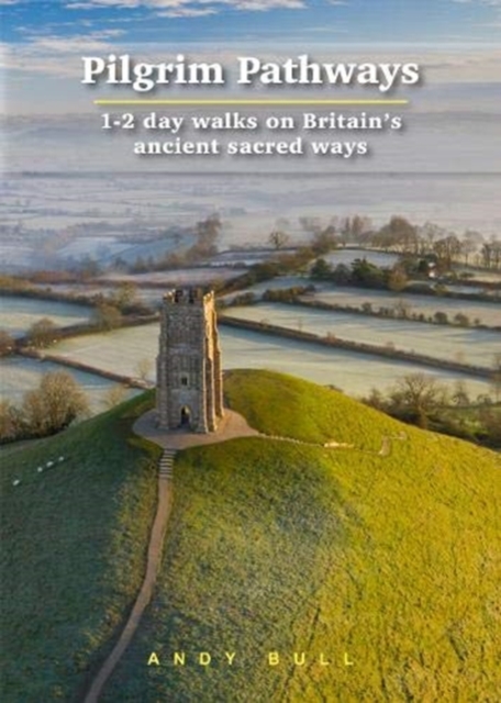
- Pilgrim Pathways: 1-2 day walks on Britain`s Ancient Sacred Ways: 2020
- Many people are inspired by the idea of going on a pilgrimage. TV series such as The Road to Rome and The Road to Santiago have shown that even the averagely unfit celeb can hobble through one. However, few of us have time for such long routes. So what to do?Pilgrim Pathways has the answer: 20 answers in fact. The pilgrimages in this guidebook... Read more
- Also available from:
- De Zwerver, Netherlands
De Zwerver
Netherlands
2020
Netherlands
2020
- Wandelgids Pilgrim Pathways | Trailblazer Guides
- Many people are inspired by the idea of going on a pilgrimage. TV series such as The Road to Rome and The Road to Santiago have shown that even the averagely unfit celeb can hobble through one. However, few of us have time for such long routes. So what to do?Pilgrim Pathways has the answer: 20 answers in fact. The pilgrimages in this guidebook... Read more

Stanfords
United Kingdom
2021
United Kingdom
2021
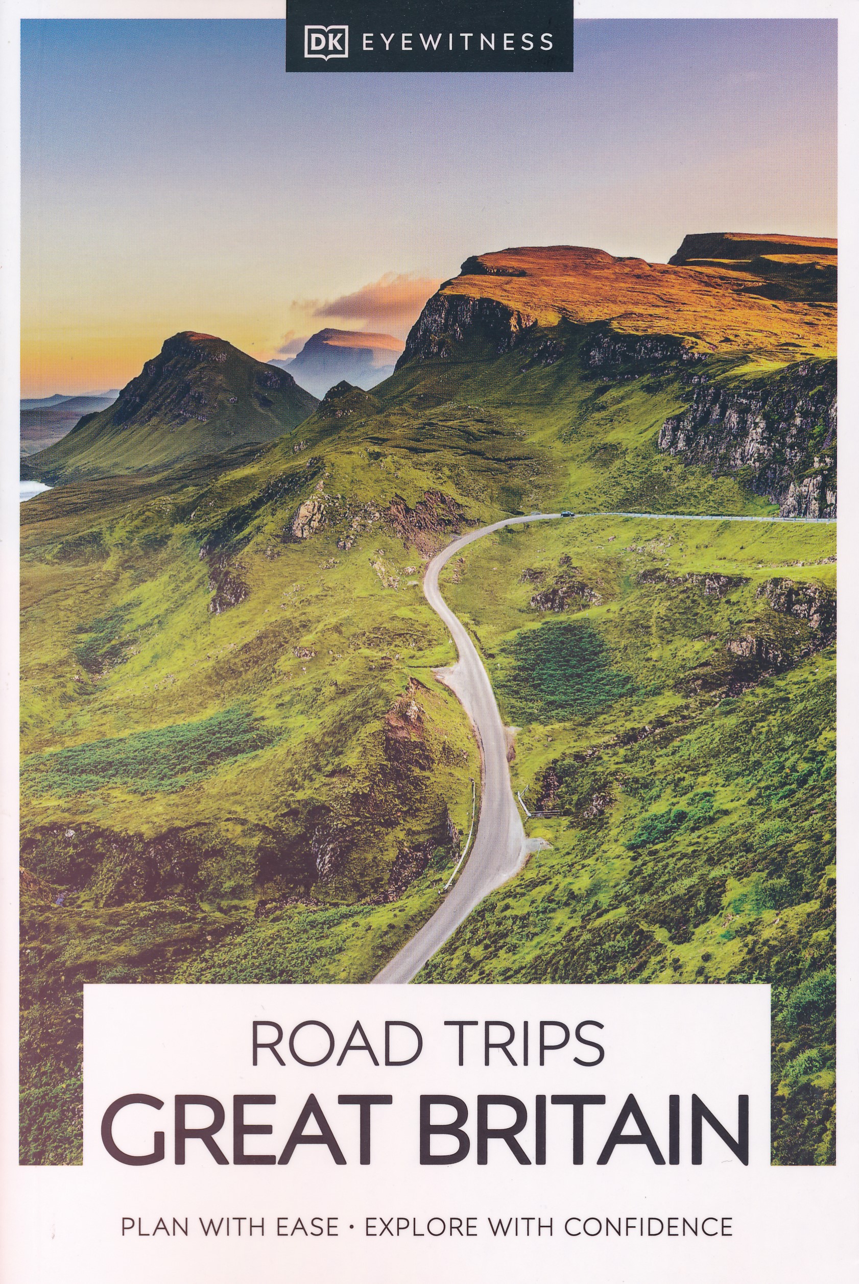
- DK Eyewitness Road Trips Great Britain
- With its idyllic market towns, romantic castle ruins and stunning natural landscapes, Great Britain is the perfect destination for a leisurely road trip. It`s yours to explore with Road Trips Great Britain, which contains 25 drives across the country, from the sweeping sandy beaches of Cornwall to the dramatic peaks of the Scottish... Read more
- Also available from:
- De Zwerver, Netherlands
De Zwerver
Netherlands
2021
Netherlands
2021
- Reisgids Road Trips Great Britain | Dorling Kindersley
- With its idyllic market towns, romantic castle ruins and stunning natural landscapes, Great Britain is the perfect destination for a leisurely road trip. It`s yours to explore with Road Trips Great Britain, which contains 25 drives across the country, from the sweeping sandy beaches of Cornwall to the dramatic peaks of the Scottish... Read more

Stanfords
United Kingdom
2021
United Kingdom
2021
- Isle of Skye
- Britain`s best-loved walking guides brings you Pathfinder (R) Guide Isle of Skye containing 28 fabulous walks exploring the rugged and romantic beauty of this celebrated and most famous Scottish island. From inspiring coastal scenery to highland peaks, and from romantic castles to crofters` cottages, routes guide walkers to the northernmost,... Read more

Stanfords
United Kingdom
United Kingdom
- The National Trust Book of the Countryside
- Explore the British countryside with the National Trust. No organisation knows more about the British countryside than the National Trust, the custodians of some of our most beautiful stretches of land and coastline. Drawing on their expertise, this stunningly illustrated book is a comprehensive guide to the country`s natural heritage. Part One... Read more

Stanfords
United Kingdom
2021
United Kingdom
2021
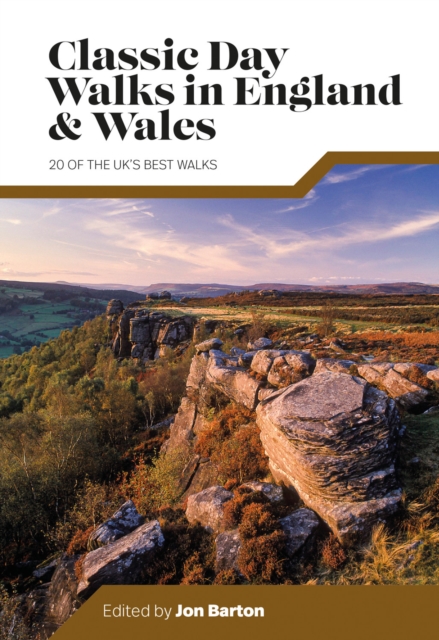
- Classic Day Walks in England & Wales: 20 of the UK`s best walks
- Classic Day Walks in England & Wales features a selection of 20 of the best day-length hillwalking routes from Vertebrate Publishing`s popular series of walking guidebooks.Edited by Jon Barton, this guidebook takes you to the best hiking country in England and Wales: take in Lake District fells, traverse Hadrian`s Wall, ramble in the South... Read more
- Also available from:
- De Zwerver, Netherlands
De Zwerver
Netherlands
2021
Netherlands
2021
- Wandelgids Day Walks Classic Day Walks in England & Wales | Vertebrate Publishing
- 20 of the UK's best walks Read more

Stanfords
United Kingdom
United Kingdom
- The Great British Bucket List
- If you want to ski off a cliff or swim with sharks, stop reading now. This book is about achievable adventures that celebrate the best of Britain and Britishness. The 60 mini adventures are graded in difficulty from comically easy to mildly challenging, making them suitable for a wide range of ages and abilities. They include the most beautiful... Read more
Maps

Stanfords
United Kingdom
United Kingdom
- Scunthorpe and Gainsborough 1824
- Map No. 112, Scunthorpe and Gainsborough 1824, in the Cassini Historical Series of old Ordnance Survey mapping of England and Wales at 1:50,000 in a format designed to offer a convenient comparison with the present day coverage from the OS, and most locations in three different editions. Old historical maps have been combined so that the sheet... Read more
Stanfords
United Kingdom
United Kingdom
- Swindon and Devizes 1898-1899
- Map No. 173, Swindon and Devizes 1898-1899, in the Cassini Historical Series of old Ordnance Survey mapping of England and Wales at 1:50,000 in a format designed to offer a convenient comparison with the present day coverage from the OS, and most locations in three different editions. Old historical maps have been combined so that the sheet... Read more
Stanfords
United Kingdom
United Kingdom
- Aberystwyth and Machynlleth 1833-1923 (3-map set)
- Map No. 135, Aberystwyth and Machynlleth 1833-1923 (3-map set), in the Cassini Historical Series of old Ordnance Survey mapping of England and Wales at 1:50,000 in a format designed to offer a convenient comparison with the present day coverage from the OS, and most locations in three different editions. Old historical maps have been combined... Read more
Stanfords
United Kingdom
United Kingdom
- Brighton & Lewes 1813-1819
- Map No. 198, Brighton and Lewes 1813-1819, in the Cassini Historical Series of old Ordnance Survey mapping of England and Wales at 1:50,000 in a format designed to offer a convenient comparison with the present day coverage from the OS, and most locations in three different editions. Old historical maps have been combined so that the sheet... Read more
Stanfords
United Kingdom
United Kingdom
- Kendal and Morecambe 1924-1925
- Map No. 97, Kendal and Morecambe 1924-1925, in the Cassini Historical Series of old Ordnance Survey mapping of England and Wales at 1:50,000 in a format designed to offer a convenient comparison with the present day coverage from the OS, and most locations in three different editions. Old historical maps have been combined so that the sheet... Read more
Stanfords
United Kingdom
United Kingdom
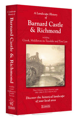
- Barnard Castle and Richmond 1860-1925 (3-map set)
- Map No. 92, Barnard Castle and Richmond 1860-1925 (3-map set), in the Cassini Historical Series of old Ordnance Survey mapping of England and Wales at 1:50,000 in a format designed to offer a convenient comparison with the present day coverage from the OS, and most locations in three different editions. Old historical maps have been combined so... Read more
Stanfords
United Kingdom
United Kingdom
- Newcastle upon Tyne 1862-1867
- Map No. 88, Newcastle upon Tyne 1862-1867, in the Cassini Historical Series of old Ordnance Survey mapping of England and Wales at 1:50,000 in a format designed to offer a convenient comparison with the present day coverage from the OS, and most locations in three different editions. Old historical maps have been combined so that the sheet... Read more
Stanfords
United Kingdom
United Kingdom
- Bristol and Bath 1899
- Map No. 172, Bristol and Bath 1899, in the Cassini Historical Series of old Ordnance Survey mapping of England and Wales at 1:50,000 in a format designed to offer a convenient comparison with the present day coverage from the OS, and most locations in three different editions. Old historical maps have been combined so that the sheet lines... Read more
Stanfords
United Kingdom
United Kingdom
- Ely and Wisbech 1824-1922 (3-map set)
- Map No. 143, Ely and Wisbech 1824-1922 (3-map set), in the Cassini Historical Series of old Ordnance Survey mapping of England and Wales at 1:50,000 in a format designed to offer a convenient comparison with the present day coverage from the OS, and most locations in three different editions. Old historical maps have been combined so that the... Read more
Stanfords
United Kingdom
United Kingdom
- Winchester and Basingstoke 1810-1817
- Map No. 185, Winchester and Basingstoke 1810-1817, in the Cassini Historical Series of old Ordnance Survey mapping of England and Wales at 1:50,000 in a format designed to offer a convenient comparison with the present day coverage from the OS, and most locations in three different editions. Old historical maps have been combined so that the... Read more
Stanfords
United Kingdom
United Kingdom
- The Black Mountains / Y Mynyddoedd Duon 1919-1920
- Map No. 161, The Black Mountains / Y Mynyddoedd Duon 1919-1920, in the Cassini Historical Series of old Ordnance Survey mapping of England and Wales at 1:50,000 in a format designed to offer a convenient comparison with the present day coverage from the OS, and most locations in three different editions. Old historical maps have been combined... Read more
Stanfords
United Kingdom
United Kingdom
- Scarborough 1856-1925 (3-map set)
- Map No. 101, Scarborough 1856-1925 (3-map set), in the Cassini Historical Series of old Ordnance Survey mapping of England and Wales at 1:50,000 in a format designed to offer a convenient comparison with the present day coverage from the OS, and most locations in three different editions. Old historical maps have been combined so that the sheet... Read more
Stanfords
United Kingdom
United Kingdom
- Barrow-in-Furness and South Lakeland 1852-1865
- Map No. 96, Barrow-in-Furness and South Lakeland 1852-1865, in the Cassini Historical Series of old Ordnance Survey mapping of England and Wales at 1:50,000 in a format designed to offer a convenient comparison with the present day coverage from the OS, and most locations in three different editions. Old historical maps have been combined so... Read more
Stanfords
United Kingdom
United Kingdom
- Northampton and Milton Keynes 1833-1920 (3-map set)
- Map No. 152, Northampton and Milton Keynes 1833-1920 (3-map set), in the Cassini Historical Series of old Ordnance Survey mapping of England and Wales at 1:50,000 in a format designed to offer a convenient comparison with the present day coverage from the OS, and most locations in three different editions. Old historical maps have been combined... Read more
Stanfords
United Kingdom
United Kingdom
- Torbay and South Dartmoor 1809
- Map No. 202, Torbay and South Dartmoor 1809, in the Cassini Historical Series of old Ordnance Survey mapping of England and Wales at 1:50,000 in a format designed to offer a convenient comparison with the present day coverage from the OS, and most locations in three different editions. Old historical maps have been combined so that the sheet... Read more