
England
Description
Map


Trails in this state
- A Dales Highway
- Allerdale RambleGPX
- Beacon WayGPX
- Borders Abbeys WayGPX
- Calderdale WayGPX
- Cheshire Ring Canal WalkGPX
- Cleveland WayGPX
- Coast to Coast WalkGPX
- Coleridge WayGPX
- Copper Trail
- Cotswold WayGPX
- Cumbria WayGPX
- Dales WayGPX
- Dartmoor WayGPX
- Downs LinkGPX
- E2GPX
- E8GPX
- Essex WayGPX
- Fen Rivers WayGPX
- Geopark WayGPX
- Greensand Ridge WalkGPX
- Greensand WayGPX
- Guernsey Coastal Path
- Hadrian's WallGPX
- Heart of England WayGPX
- Hereward WayGPX
- High Weald Landscape TrailGPX
- Icknield WayGPX
- Isle of Jersey Coastal Path
- Isle of Man Coastal PathGPX
- Isle of Wight Coastal PathGPX
- Lady Anne's WayGPX
- Lands End to John o'GroatsGPX
- Lea Valley WalkGPX
- Leland TrailGPX
- Liberty TrailGPX
- Limestone LinkGPX
- Limestone WayGPX
- Mendip WayGPX
- Minster WayGPX
- Monarch's WayGPX
- Nene WayGPX
- North Buckinghamshire WayGPX
- North Downs WayGPX
- North Sea TrailGPX
- Northumberland Coast PathGPX
- Offa's Dyke PathGPX
- Oxford Canal WalkGPX
- Oxfordshire WayGPX
- Peddars Way and Norfolk Coast PathGPX
- Pendle WayGPX
- Pennine BridlewayGPX
- Pennine WayGPX
- Quantock GreenwayGPX
- Reivers Way
- Ribble WayGPX
- RidgewayGPX
- Robin Hood WayGPX
- Saint Cuthbert's WayGPX
- Saint Oswald's Way
- Saints WayGPX
- Saxon Shore WayGPX
- Severn WayGPX
- Shakespeare's WayGPX
- Shropshire WayGPX
- Solent WayGPX
- South Downs WayGPX
- South West Coast PathGPX
- Staffordshire WayGPX
- Stour Valley PathGPX
- Suffolk Coast and Heaths Path
- Tamar Valley Discovery TrailGPX
- Tarka TrailGPX
- Teesdale WayGPX
- Thames PathGPX
- Trans Pennine TrailGPX
- Two Moors WayGPX
- Via FrancigenaGPX
- Viking WayGPX
- Wayfarer's WalkGPX
- WealdwayGPX
- Weavers WayGPX
- Windermere WayGPX
- Worcestershire WayGPX
- Wychavon WayGPX
- Yorkshire Wolds WayGPX
Links
Facts
Reports
Guides and maps
Lodging
Organisations
Tour operators
GPS
Other
Books

Stanfords
United Kingdom
United Kingdom
- West Sussex - Year Round Walks
- These 20 circular walks vary in length from 41/2 to 71/2 miles and are enjoyable all year round. The author has divided the routes into seasons to show each at its very best. There are walks over Harting Downs, The Trundle and the South Downs Way, all with superb views; through the majestic woodland of Northpark Copse and Eartham Wood; and... Read more

Stanfords
United Kingdom
2019
United Kingdom
2019
- Pennine Way: Edale to Kirk Yetholm
- Britain`s best-known National Trail winds for 256 miles through three National Parks - the Peak District, Yorkshire Dales and Northumberland. This is the 5th edition. This superb footpath showcases Britain`s finest upland scenery, while touching the literary landscape of the Bronte family and Roman history along Hadrian`s Wall. *138 large-scale... Read more

Stanfords
United Kingdom
United Kingdom
- Thames Valley - 20 Country Walks For All The Family
- An exciting new gift series of walking guides, aimed at the weekend, family walker. These small-format, portable hardback books have an attractive retro feel, with nostalgic line drawings and hand-drawn maps. Each of the 20 walks have been carefully selected to appeal to family walkers, most are circular and none are too strenuous. Each walk... Read more

Stanfords
United Kingdom
United Kingdom
- Walking The Invisible: Following in the Brontës` Footsteps
- Michael Stewart has been captivated by the Brontës since he was a child, and has travelled all over the north of England in search of their lives and landscapes. Now, he`d like to invite you into the world as they would have seen it. Following in the footsteps of the Brontës across meadow and moor, through village and town,... Read more

Stanfords
United Kingdom
United Kingdom
- Essex - Pub Walks
- If you enjoy both walking and visiting country pubs this book is for you. It contains 20 circular routes varying in length from 2 to 61/2 miles. At the heart of each walk is a renowned local pub, all of which have been recommended for their good food and warm welcome.The routes include coastal and riverside walks, visits to attractive villages... Read more

Stanfords
United Kingdom
United Kingdom
- West Sussex: A Dog Walker`s Guide
- A leisurely stroll in the countryside is always a pleasure for dog walkers. But after leaving the familiar local routes there are always the worries of suddenly finding a field full of sheep, or a busy road, not to mention the difficulty of knowing which pubs and cafes will welcome dogs. Here is a collection of 20 tried and tested circular... Read more

Stanfords
United Kingdom
United Kingdom
- Britain`s Best Coastal Walks
- Accompanied by beautiful colour photography, ”Britain`s Best Coastal Walks” celebrates the varied treasures to be found on the coastlines of England, Wales and Scotland. Andrew McCloy has devised 15 two- to three-day walks along sections of Britain`s most famous coastal paths, which are shown on clear and detailed maps. His commentaries focus... Read more

Stanfords
United Kingdom
United Kingdom
- Walks Along the East Jurassic Coast - Studland to Portland
- From the Publisher of the highly acclaimed Jurassic Coast Official Guide, Coastal Publishing Limited is a fast growing publisher with an expanding list of books of regional interest and national appeal. Walks Along the East Jurassic Coast and its companion Walks Along the West Jurassic Coast Are the first two books in a series of 11 walking... Read more

Stanfords
United Kingdom
United Kingdom
- Everybody Loves Porto
- Porto has the look of a city that’s had its ups and downs, but its beauty shines through in tile-covered buildings, unaltered shop fronts from decades past and the winding streets that tumble down to the sparkling Duoro river.But more than just elegant decay, it’s also a city in the ascendant, home to new, young businesses providing a fresh... Read more

Stanfords
United Kingdom
United Kingdom
- A Journey Through South-East England: Broadstairs to Lewes
- A Journey Through South-East England:Broadstairs to Lewes follows Brian`s latest walking adventures through the South-East of England. Brian has previously walked over 1,000 miles for his last two walking companion guide books, Finding My Place and Walking My Patch. In this book, Brian shares the details of four complex walks: Broadstairs to... Read more

Stanfords
United Kingdom
United Kingdom
- Coastlines: The Story of Our Shore
- From one of the most engaging and widely admired of the new generation of nature writers, here is a portrait of the British coastline from the Giant`s Causeway to Land`s End.Told through a series of walks beside the sea, this is the story of the most beautiful 742 miles of coastline in England, Wales and Northern Ireland-its rocks, plants and... Read more
Stanfords
United Kingdom
United Kingdom
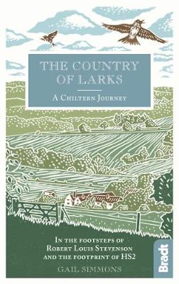
- Country of Larks: A Chiltern Journey: In the footsteps of Robert Louis Stevenson and the footprint of HS2
- Shortlisted for the 2020 Edward Stanford Travel Writing Award`s Lonely Planet Debut Travel Writer of the YearTravel writer and journalist Gail Simmons follows in the footsteps of Robert Louis Stevenson as she walks from High Wycombe in Buckinghamshire to Tring in Hertfordshire via Great Missenden and Wendover, tracing not only the changes in... Read more

Stanfords
United Kingdom
United Kingdom
- Colors of Fall Road Trip Guide - 25 Autumn Tours in New England
- This guide details 25 of the best scenic tours during fall foliage season in New England. Trips vary from short drives on the coast to all-day excursions in the region`s mountains and forests. Detailed maps and itineraries complement trip descriptions that tell you what you`ll find along the route. In addition, sidebars suggest short walks and... Read more

Stanfords
United Kingdom
United Kingdom
- South Downs - 20 Country Walks For All The Family
- Batsford`s Walking Guides is an exciting new gift series of walking books, aimed at the weekend, family walker. These small-format, portable, hardback books have an attractive retro feel, with nostalgic line drawings and hand-drawn maps. Each of the 20 walks have been carefully selected to appeal to family walkers, most are circular and none... Read more

Stanfords
United Kingdom
United Kingdom
- River Thames & Thames Path Heron Map
- This tourist map of the River Thames and Thames Path covers from its source, just outside Kemble in Gloucestershire, to the Thames Barrier at 1:55,000, with detailed town plans of Lechlade, Oxford, Abingdon, Wallingford, Henley-on-Thames, central Reading, Windsor and Eton, Marlow and Kingston upon Thames at 1:12,500. The Thames and Severn Canal... Read more
Maps

Stanfords
United Kingdom
United Kingdom
- Oxford 1919
- Map No. 164, Oxford 1919, in the Cassini Historical Series of old Ordnance Survey mapping of England and Wales at 1:50,000 in a format designed to offer a convenient comparison with the present day coverage from the OS, and most locations in three different editions. Old historical maps have been combined so that the sheet lines correspond to... Read more
Stanfords
United Kingdom
United Kingdom
- Kidderminster and Wyre Forest 1831-1834
- Map No. 138, Kidderminster and Wyre Forest 1831-1834, in the Cassini Historical Series of old Ordnance Survey mapping of England and Wales at 1:50,000 in a format designed to offer a convenient comparison with the present day coverage from the OS, and most locations in three different editions. Old historical maps have been combined so that the... Read more
Stanfords
United Kingdom
United Kingdom
- Elan Valley and Builth Wells / Cwm Elan a Llanfair-ym-Muallt 1900-1903
- Map No. 147, Elan Valley and Builth Wells / Cwm Elan a Llanfair-ym-Muallt 1900-1903, in the Cassini Historical Series of old Ordnance Survey mapping of England and Wales at 1:50,000 in a format designed to offer a convenient comparison with the present day coverage from the OS, and most locations in three different editions. Old historical maps... Read more
Stanfords
United Kingdom
United Kingdom
- Taunton and Lyme Regis 1809-1919 (3-map set)
- Map No. 193, Taunton and Lyme Regis 1809-1919 (3-map set), in the Cassini Historical Series of old Ordnance Survey mapping of England and Wales at 1:50,000 in a format designed to offer a convenient comparison with the present day coverage from the OS, and most locations in three different editions. Old historical maps have been combined so... Read more
Stanfords
United Kingdom
United Kingdom
- Ludlow / Llwydlo & Church Stretton 1920-1921 - 137
- Map No. 137, Church Stretton and Ludlow / Llwydlo 1920-1921, in the Cassini Historical Series of old Ordnance Survey mapping of England and Wales at 1:50,000 in a format designed to offer a convenient comparison with the present day coverage from the OS, and most locations in three different editions. Old historical maps have been combined so... Read more
Stanfords
United Kingdom
United Kingdom
- Ludlow / Llwydlo & Church Stretton 1901-1903 - 137
- Map No. 137, Church Stretton and Ludlow / Llwydlo 1901-1903, in the Cassini Historical Series of old Ordnance Survey mapping of England and Wales at 1:50,000 in a format designed to offer a convenient comparison with the present day coverage from the OS, and most locations in three different editions. Old historical maps have been combined so... Read more

Stanfords
United Kingdom
United Kingdom
- Kidderminster and Stourport-on-Severn Past and Present
- Kiddermister and Stourport-on-Severn in the Cassini Past and Present map series which covers town and cities of England and Wales and offers a unique way of tracing their history and expansion by showing four different periods of their development using Ordnance Survey mapping from the mid-19th century, the late 19th century, the 1920s and the... Read more
Stanfords
United Kingdom
United Kingdom
- Dorchester and Weymouth 1919
- Map No. 194, Dorchester and Weymouth 1919, in the Cassini Historical Series of old Ordnance Survey mapping of England and Wales at 1:50,000 in a format designed to offer a convenient comparison with the present day coverage from the OS, and most locations in three different editions. Old historical maps have been combined so that the sheet... Read more

Stanfords
United Kingdom
United Kingdom
- Val d`Arbia, Ombrone and Orcia
- The valleys of Arbia, Ombrone and Orcia in Tuscany directly south of Siena on a detailed contoured map at 1:50,000 from Litografia Artistica Cartografica highlighting the course of La Via Francigena and other waymarked local trails.The map covers an area from Siena southwards to Castel del Piano including several nature reserves. Topography is... Read more
Stanfords
United Kingdom
United Kingdom
- Plymouth and Launceston 1809-1919 (3-map set)
- Map No. 201, Plymouth and Launceston 1809-1919 (3-map set), in the Cassini Historical Series of old Ordnance Survey mapping of England and Wales at 1:50,000 in a format designed to offer a convenient comparison with the present day coverage from the OS, and most locations in three different editions. Old historical maps have been combined so... Read more
Stanfords
United Kingdom
United Kingdom
- Northallerton and Ripon 1903-1904
- Map No. 99, Northallerton and Ripon 1903-1904, in the Cassini Historical Series of old Ordnance Survey mapping of England and Wales at 1:50,000 in a format designed to offer a convenient comparison with the present day coverage from the OS, and most locations in three different editions. Old historical maps have been combined so that the sheet... Read more

Stanfords
United Kingdom
United Kingdom
- Derby Past and Present
- Derby in the Cassini Past and Present map series which covers town and cities of England and Wales and offers a unique way of tracing their history and expansion by showing four different periods of their development using Ordnance Survey mapping from the mid-19th century, the late 19th century, the 1920s and the present day. Coverage includes... Read more
Stanfords
United Kingdom
United Kingdom
- The Black Mountains / Y Mynyddoedd Duon 1830-1920 (3-map set)
- Map No. 161, The Black Mountains / Y Mynyddoedd Duon 1830-1920 (3-map set), in the Cassini Historical Series of old Ordnance Survey mapping of England and Wales at 1:50,000 in a format designed to offer a convenient comparison with the present day coverage from the OS, and most locations in three different editions. Old historical maps have... Read more
Stanfords
United Kingdom
United Kingdom
- Gloucester and the Forest of Dean 1919
- Map No. 162, Gloucester and the Forest of Dean 1919, in the Cassini Historical Series of old Ordnance Survey mapping of England and Wales at 1:50,000 in a format designed to offer a convenient comparison with the present day coverage from the OS, and most locations in three different editions. Old historical maps have been combined so that the... Read more
Stanfords
United Kingdom
United Kingdom
- Gloucester and the Forest of Dean 1899-1900
- Map No. 162, Gloucester and the Forest of Dean 1899-1900, in the Cassini Historical Series of old Ordnance Survey mapping of England and Wales at 1:50,000 in a format designed to offer a convenient comparison with the present day coverage from the OS, and most locations in three different editions. Old historical maps have been combined so that... Read more