Himalayas
Description
Links
Facts
Reports
Guides and maps
Lodging
Organisations
Tour operators
GPS
Other
Books

Stanfords
United Kingdom
United Kingdom
- From the Lion`s Mouth: A Journey Along the Indus
- Shortlisted for the 2020 Edward Stanford Travel Writing Award`s Steppes Travel Adventure Travel Book of the YearIain Campbell has been fascinated by mountains for as long as he can remember. In his new book, he tells the story of a journey following the course of the Indus River from its mouth in the mudflats of Karachi through the Karakorum,... Read more
- Also available from:
- The Book Depository, United Kingdom


The Book Depository
United Kingdom
2013
United Kingdom
2013
- A Walk in the Clouds
- 75 short stories of adventures among the mountains of the world Read more

The Book Depository
United Kingdom
United Kingdom
- Nepal Himalaya: The Most Mountainous of a Singularly Mountainous Country
- The Most Mountainous of a Singularly Mountainous Country Read more


The Book Depository
United Kingdom
2020
United Kingdom
2020
- Also available from:
- De Zwerver, Netherlands


The Book Depository
United Kingdom
United Kingdom
- The Great Himalaya Trail N3
- The Rara, Jumla & Mugu Section Read more


Stanfords
United Kingdom
2018
United Kingdom
2018
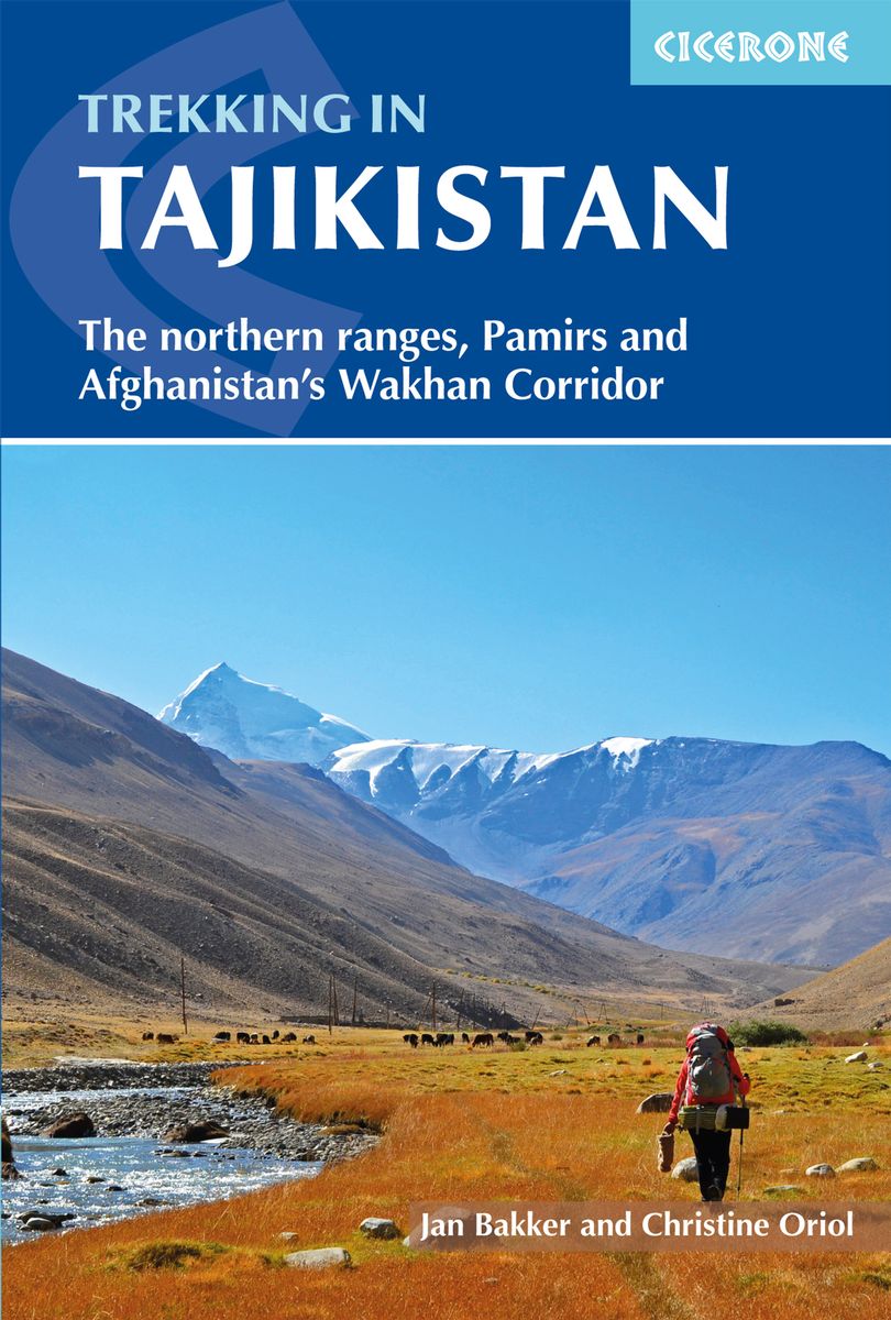
- Trekking in Tajikistan: The northern ranges, Pamirs and Afghanistan`s Wakhan Corridor
- This guide describes twenty high-altitude treks of 2-9 days in the mountains of Tajikistan, covering the Fann Mountains, Pamirs and northern ranges, plus five day hikes near the capital, Dushanbe, and a 10-day trek in the Afghan Wakhan Corridor. As well as detailed route description and 1:100,000 mapping for each trek, there is a wealth of... Read more
- Also available from:
- The Book Depository, United Kingdom
- De Zwerver, Netherlands

The Book Depository
United Kingdom
2018
United Kingdom
2018
- Trekking in Tajikistan
- The northern ranges, Pamirs and Afghanistan's Wakhan Corridor Read more
De Zwerver
Netherlands
2019
Netherlands
2019
- Wandelgids Trekking in Tajikistan - Tadzjikistan | Cicerone
- Guidebook to trekking in Tajikistan and Afghanistan. Contains 21 treks exploring 5 different mountain areas, including the Northern Ranges, Pamir Mountains and Afghanistan's Wakhan Corridor. Also includes a handful of shorter day hikes. With advice on trekking, backpacking equipment, permits and visas, and transport. Read more


Bol.com
Netherlands
Netherlands
- DK Eyewitness Travel Guide
- This lavishly illustrated guide is the perfect accompaniment for your trip to India, with regional coverage stretching from the Great Himalayas of the north to the tropical peninsular of the south. Packed with 3D aerial views, cutaways and floorplans of all the major sites, and now with even more full-colour maps of towns and regions, you can... Read more
- Also available from:
- Bol.com, Belgium
Bol.com
Belgium
Belgium
- DK Eyewitness Travel Guide
- This lavishly illustrated guide is the perfect accompaniment for your trip to India, with regional coverage stretching from the Great Himalayas of the north to the tropical peninsular of the south. Packed with 3D aerial views, cutaways and floorplans of all the major sites, and now with even more full-colour maps of towns and regions, you can... Read more
Maps

Stanfords
United Kingdom
United Kingdom
- Solu Khumbu - Everest Region Great Himayala Trail Map
- Solu Khumbu/Everest Region, map no. 103, at 1:100,000 on a waterproof and tear-resistant trekking map from the Himalayan MapHouse in their series covering the whole of northern Nepal. The map highlights main trekking routes from Lukla, both north and south of the town: Everest Base Camp Trek, alternative routes to the Gokyo Lakes, Bhote Koshi... Read more

Stanfords
United Kingdom
United Kingdom
- Mustang Great Himalaya Trail Map
- Mustang, map no. 108, at 1:100,000 on a waterproof and tear-resistant trekking map from the Himalayan MapHouse in their series covering the whole of northern Nepal. The map shows the region north of the upper section of the Annapurna Circuit, beyond Jomsom/Jomosom and Muktinath, and highlights the route to Garphu, the Mustang to Phu trek, the... Read more

Stanfords
United Kingdom
United Kingdom
- Kailash
- Mount Kailash (Kang Rinpoche / Kang Tise) on a contoured and GPS compatible map at 1:50,000 from Swiss publishers Gecko Maps, with a plan of Darchen and an overview map of Tibet, plus on the reverse a panorama map of the area.The map is centred on the peak of Kailash and extends northwards from the approach road from Lhasa to Darchen, beyond... Read more

Stanfords
United Kingdom
United Kingdom
- Rolwaling Region Great Himalaya Trail Map SUPERCEDED
- The Rolwaling, map no. 104, at 1:100,000 on a waterproof and tear-resistant trekking map from the Himalayan MapHouse in their series covering the whole of northern Nepal. The map highlights main trekking routes from Jiri, both north and south of the town, including the first sections of the Jiri/Everest and Jiri/Pikey Peak trails, the Numbur... Read more

Stanfords
United Kingdom
United Kingdom
- Kanchenjunga Region Great Himalaya Trail Map
- Kanchenjunga Region, map no. 101, at 1:100,000 on a waterproof and tear-resistant trekking map from the Himalayan MapHouse in their series covering the whole of northern Nepal. The map highlights main trekking routes from Taplejung, including Kanchenjunga Base Camp Trek, Yalung Base Camp Trek, Phathibhara Trek, the route along the Yangma Khola... Read more

Stanfords
United Kingdom
United Kingdom
- Makalu Region Great Himalay Trail Map
- Makalu Region, map no. 102, at 1:100,000 on a waterproof and tear-resistant trekking map from the Himalayan MapHouse in their series covering the whole of northern Nepal. The map highlights main trekking routes from Tumlingtar northwards: the Makalu Base Camp Trek and the route to Kimathangka, a local route east of the town, plus the relevant... Read more

Stanfords
United Kingdom
United Kingdom
- Rolwaling Region Great Himalaya Trail Map
- The Rolwaling, map no. 104, at 1:100,000 on a waterproof and tear-resistant trekking map from the Himalayan MapHouse in their series covering the whole of northern Nepal. The map highlights main trekking routes from Jiri, both north and south of the town, including the first sections of the Jiri/Everest and Jiri/Pikey Peak trails, the Numbur... Read more

Stanfords
United Kingdom
United Kingdom
- Everest Base Camp & Gokyo - Three Passes 50K
- Everest Base Camp - Gokyo - Three Passes Trek map at 1:50,000 from Nepa Maps prominently highlighting the Three Passes Trek from Lukla and Namche along a section of the Everest Trek via Tengboche and Dingboche to the Thokla Pass, then westwards to the Cho (Chhugyuma) La Pass, Gokyo Lake and the Rejno La Pass, and southwards back to Namche via... Read more

Stanfords
United Kingdom
United Kingdom
- Monastry Circuit Trail
- The Monastery Trail south of Lukla at 1:100,000 in the Nepa Maps series which provides extensive coverage of trekking areas of Nepal on detailed contoured maps with trekking routes and hiking trails, huts and camp sites, local places of interest and other tourist information.The map covers an area from Namche Bazar southwards along the Dudh... Read more
De Zwerver
Netherlands
Netherlands
De Zwerver
Netherlands
Netherlands
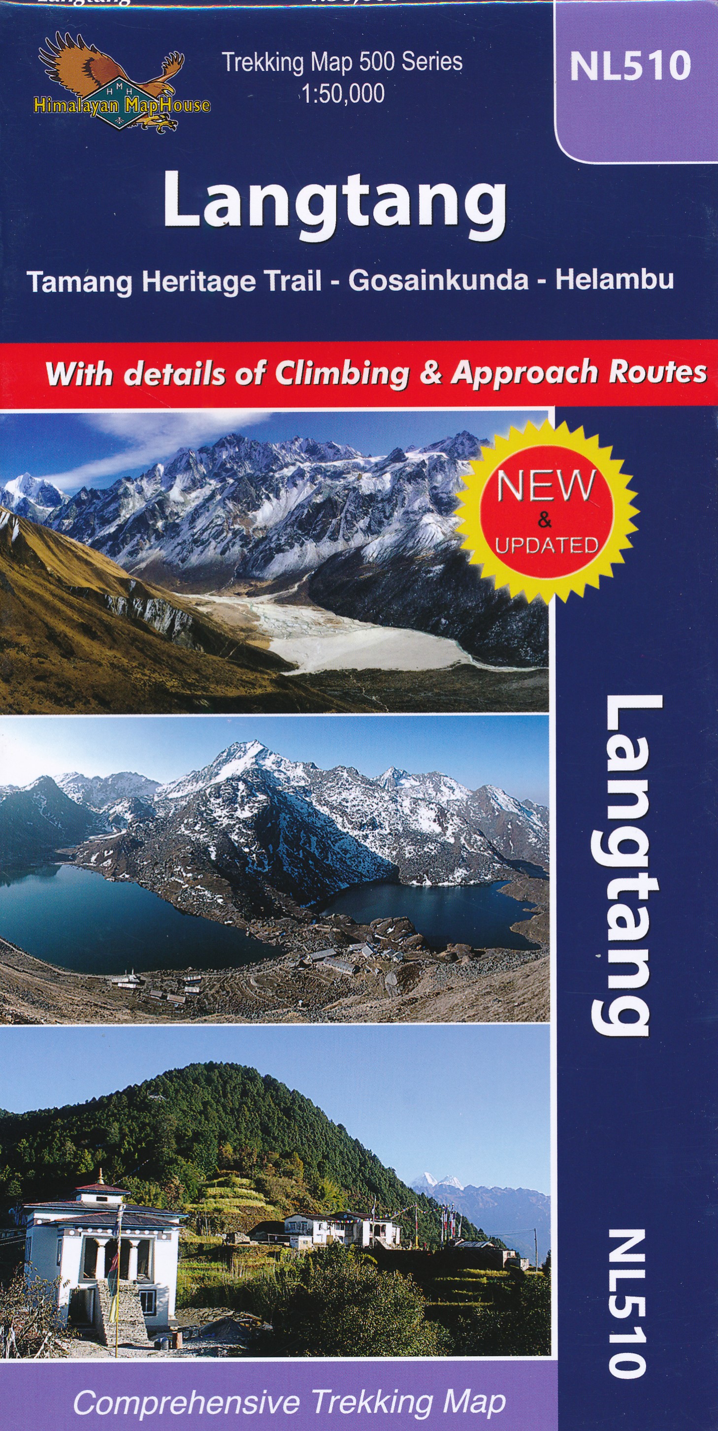
- Wandelkaart NL510 Langtang | Himalayan Maphouse
- Langtang - Tamang Heritage Trail - Gosainkunda – Helambu area at 1:50,000 on a double-sided, contoured and GPS compatible map from Nepa Maps/Himalayan Map House. Coverage extends from Kathmandu northwards beyond Dunche and Langtang to the peak and the Base Camp of Langtang Lirung. Contour interval is 40 metres, enhanced by relief shading and... Read more
De Zwerver
Netherlands
2017
Netherlands
2017
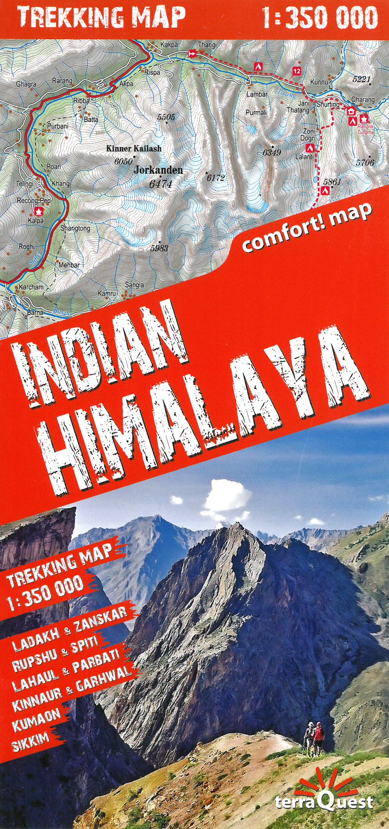
- Wandelkaart Trekking map Indian Himalaya | TerraQuest
- Mooie gedetailleerde kaart, geplastificeerd. De kaart heeft op de ene kant een algemeen overzicht van de Indische Himalaya met schaal 1/750.000 en op de andere zijde vind je de 22 trekking routes op schaal 1/350.000. Op zich geen zeer gedetailleerde wandelkaart. Er van uitgaande dat je de tochten toch met een gids of met een groep doet, dan is... Read more
De Zwerver
Netherlands
Netherlands
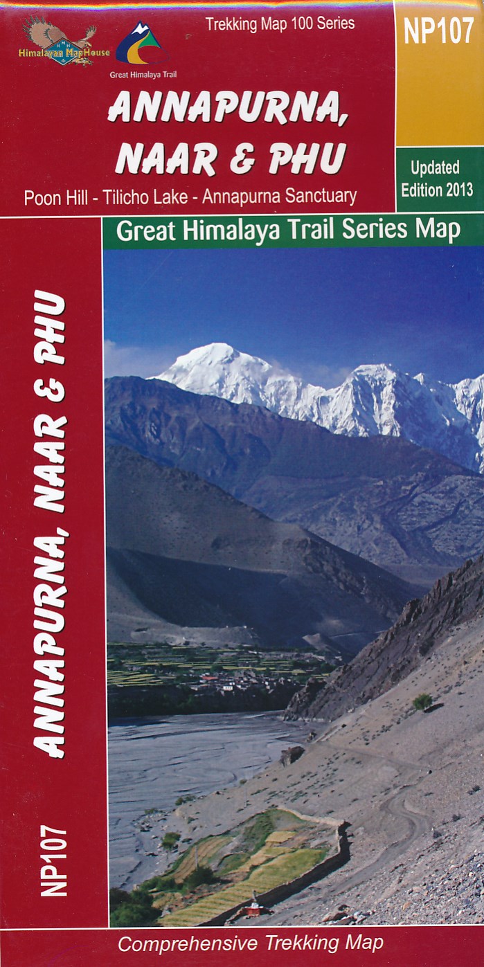
- Wandelkaart NP Annapurna, Naar & Phu - Nepal | Himalayan Maphouse
- Zeer gedetailleerde topografische wandelkaart. Dit is een nieuwe serie kaarten die de Great Himalaya Trail (GHT) in Nepal volgt. Kaart 1 begint in het oosten van Nepal, de volgende kaarten lopen richting noordwest tot India. Watervaste trekkingkaart met ingetekende GHT High route en andere belangrijke trekkingroutes in de omgeving: GHT Cultural... Read more
De Zwerver
Netherlands
Netherlands
More maps…