Virginia
Description
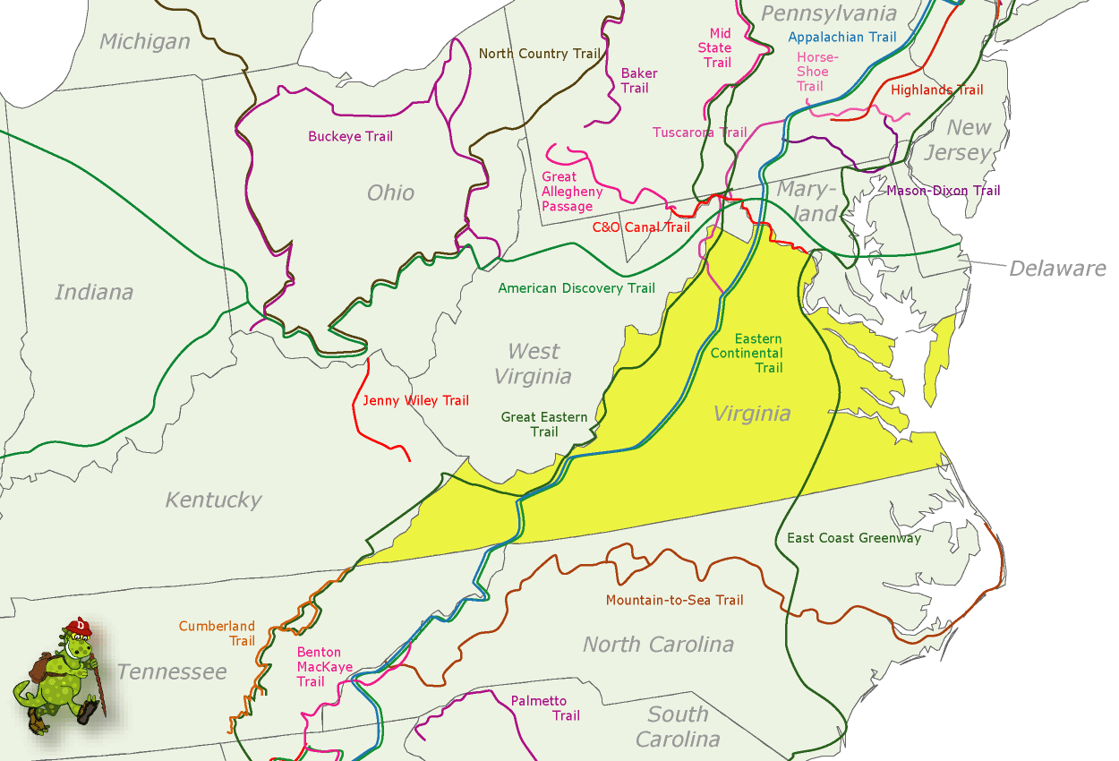
Virginia, on the Atlantic Ocean, hosts a large part of the Appalachian Trail, some 550 miles.
Other lengthy long distance trails passing through Virginia are the East Coast Greenway, the Eastern Continental Trail and the Great Eastern Trail.
The Tuscarora Trail is 252 miles long, and besides Virginia, it runs across Maryland, Pennsylvania and West Virginia. Also with West Virginia, it shares the Allegheny Trail, 330 miles.
Parks of interest for hiking are the Shenandoah National Park and Jefferson National Forest, both in the Blue Ridge Mountains, and the Washington National Forest.
Map
Trails in this state
Links
Facts
Reports
Guides and maps
Lodging
Organisations
Tour operators
GPS
Other
Books

Stanfords
United Kingdom
United Kingdom
- World Awesome Maps Hiking Wall Map
- Illustrated world map with the best hiking trails across the globe. Over 300 trails, from short glacier walks like the Perito Moreno Glacier Walk in Argentina to long-distance treks like the Appalachian Trail and Bibbulmun Track in Australia to lesser known remote trails like the Huahuash Circuit in Peru.- High quality offset print on... Read more

Stanfords
United Kingdom
United Kingdom
- The Wild Atlantic Way Route Atlas - Ireland West
- The Wild Atlantic Way is a 25,000 kilometre coastal route along Ireland’s Atlantic coast that stretches between the southerly point of Kinsale, County Cork up to Derry. This route is favoured by many in its entirety or broken down into more manageable, day trip sections. This Xploreit handy sized spiral bound route atlas contains 30 easy-to-use... Read more

Stanfords
United Kingdom
United Kingdom
- A Horse Walks into a Bar
- The setting is a comedy club in a small Israeli town. An audience that has come expecting an evening of amusement instead sees a comedian falling apart on stage; an act of disintegration, a man crumbling, as a matter of choice, before their eyes. They could get up and leave, or boo and whistle and drive him from the stage, if they were not so... Read more

Stanfords
United Kingdom
United Kingdom
- Blur Ridge Parkway: Northern Section
- The northern section of the Blue Ridge Parkway and the surrounding area of the Appalachian Mountains on a double-sided map at 1:135,000 approx. from Outdoor Paths Publishing highlighting facilities along the route. The map covers the first part of the Parkway, from Milepost 0 to 123.Topography of the area is shown by relief shading based on the... Read more
Stanfords
United Kingdom
United Kingdom
- Blur Ridge Parkway Southern Section
- The northern section of the Blue Ridge Parkway and the surrounding area of the Appalachian Mountains on a double-sided map at 1:135,000 approx. from Outdoor Paths Publishing highlighting facilities along the route. The map covers the first part of the Parkway, from Milepost 0 to 123.Topography of the area is shown by relief shading based on the... Read more

The Book Depository
United Kingdom
United Kingdom
- Five-Star Trails: Tri-Cities of Tennessee & Virginia
- 40 Spectacular Hikes near Johnson City, Kingsport, and Bristol Read more
- Also available from:
- De Zwerver, Netherlands

The Book Depository
United Kingdom
United Kingdom
- A Walk for Sunshine
- A 2,160-Mile Expedition for Charity on the Appalachian Trail Read more
- Also available from:
- De Zwerver, Netherlands

The Book Depository
United Kingdom
United Kingdom
- The Appalachian Trail, Step by Step
- How to Prepare for a Thru or Long Distance Section Hike Read more

The Book Depository
United Kingdom
United Kingdom
- Life-changing Adventure Of Man Hiking Through The Appalachian Trail
- Real Adventure Story Read more
More books…
Maps

Stanfords
United Kingdom
United Kingdom
- Phoksundo Tal
- Phoksundo Tal, sheet no. 2982-16, in the topographic survey of Nepal at 1:50,000 published by the Nepali Government in the late 1990s and early 2000s and produced from remote sensing data by Finnish cartographers as part of that country’s international aid program. The maps cover 15’ x 15’ quadrangles.IMPORTANT – PLEASE NOTE BEFORE ORDERING:... Read more

Stanfords
United Kingdom
United Kingdom
- New York City High 5 Edition Street Plan
- The first water-resistant “Comfort Map“ with direct access to useful additional information from the InternetThe world-famous Manhattan district in a scale of 1:16,000 and an overview of New York City in a scale of 1:75,000 presented on a practical map; inclusive of the High 5 Edition app technology for calling up additional travel information... Read more

Stanfords
United Kingdom
United Kingdom
- Kalanga Bajar (Jumla)
- Kalanga Bajar (Jumla), sheet no. 2982-09, in the topographic survey of Nepal at 1:50,000 published by the Nepali Government in the late 1990s and early 2000s and produced from remote sensing data by Finnish cartographers as part of that country’s international aid program. The maps cover 15’ x 15’ quadrangles.IMPORTANT – PLEASE NOTE BEFORE... Read more

Stanfords
United Kingdom
United Kingdom
- Rasuwagadhi
- Rasuwagadhi, sheet no. 2885-10, in the topographic survey of Nepal at 1:50,000 published by the Nepali Government in the late 1990s and early 2000s and produced from remote sensing data by Finnish cartographers as part of that country’s international aid program. The maps cover 15’ x 15’ quadrangles.IMPORTANT – PLEASE NOTE BEFORE ORDERING:... Read more

Stanfords
United Kingdom
United Kingdom
- Mt. Cho Oyu - Pasan Lhamu Chuli
- Mt Cho Oyu - Pasan lhamu Chuli, sheet no. 2886-15, in the topographic survey of Nepal at 1:50,000 published by the Nepali Government in the late 1990s and early 2000s and produced from remote sensing data by Finnish cartographers as part of that country’s international aid program. The maps cover 15’ x 15’ quadrangles.IMPORTANT – PLEASE NOTE... Read more

Stanfords
United Kingdom
United Kingdom
- Bagarchhap
- Bagarchhap, sheet no. 2884-06, in the topographic survey of Nepal at 1:50,000 published by the Nepali Government in the late 1990s and early 2000s and produced from remote sensing data by Finnish cartographers as part of that country’s international aid program. The maps cover 15’ x 15’ quadrangles.IMPORTANT – PLEASE NOTE BEFORE ORDERING:... Read more
Stanfords
United Kingdom
United Kingdom
- Nepal Survey 1:25,000 Sheet 2883 11B (Tatopani)
- Koban, sheet no. 2883-07, in the topographic survey of Nepal at 1:50,000 published by the Nepali Government in the late 1990s and early 2000s and produced from remote sensing data by Finnish cartographers as part of that country’s international aid program. The maps cover 15’ x 15’ quadrangles.IMPORTANT – PLEASE NOTE BEFORE ORDERING:... Read more

Stanfords
United Kingdom
United Kingdom
- Araniko Chuli
- Araniko Chuli, sheet no. 2983-11/15, in the topographic survey of Nepal at 1:50,000 published by the Nepali Government in the late 1990s and early 2000s and produced from remote sensing data by Finnish cartographers as part of that country’s international aid program. The maps cover 15’ x 15’ quadrangles.IMPORTANT – PLEASE NOTE BEFORE ORDERING:... Read more

Stanfords
United Kingdom
United Kingdom
- Mount Makalu
- Mount Makalu, sheet no. 2787-01, in the topographic survey of Nepal at 1:50,000 published by the Nepali Government in the late 1990s and early 2000s and produced from remote sensing data by Finnish cartographers as part of that country’s international aid program. The maps cover 15’ x 15’ quadrangles.IMPORTANT – PLEASE NOTE BEFORE ORDERING:... Read more

Stanfords
United Kingdom
United Kingdom
- Chhedhul Gumba
- Chhedhul Gumba, sheet no. 2883-01, in the topographic survey of Nepal at 1:50,000 published by the Nepali Government in the late 1990s and early 2000s and produced from remote sensing data by Finnish cartographers as part of that country’s international aid program. The maps cover 15’ x 15’ quadrangles.IMPORTANT – PLEASE NOTE BEFORE ORDERING:... Read more

Stanfords
United Kingdom
United Kingdom
- Gaurishankar Himal
- Gaurishankar Himal, sheet no. 2786-02, in the topographic survey of Nepal at 1:50,000 published by the Nepali Government in the late 1990s and early 2000s and produced from remote sensing data by Finnish cartographers as part of that country’s international aid program. The maps cover 15’ x 15’ quadrangles.IMPORTANT – PLEASE NOTE BEFORE... Read more

Stanfords
United Kingdom
United Kingdom
- Olanchungola
- Olanchungola, sheet no. 2787-08, in the topographic survey of Nepal at 1:50,000 published by the Nepali Government in the late 1990s and early 2000s and produced from remote sensing data by Finnish cartographers as part of that country’s international aid program. The maps cover 15’ x 15’ quadrangles.IMPORTANT – PLEASE NOTE BEFORE ORDERING:... Read more

Stanfords
United Kingdom
United Kingdom
- World Maps International Political Wall Map X-LARGE MAGNETIC-BOARD FRAMED
- Framed, 198 x 122cm (6ft 6’’ x 4ft approx.) version of the extra large political map of the world from Maps International mounted on *magnetic board* to which magnetic makers can be attached. Countries are shown in bright vivid colours against light blue oceans. Country names are in large, clearly legible print. English versions of all city... Read more

Stanfords
United Kingdom
United Kingdom
- Dhime
- Dhime, sheet no. 2882-01, in the topographic survey of Nepal at 1:50,000 published by the Nepali Government in the late 1990s and early 2000s and produced from remote sensing data by Finnish cartographers as part of that country’s international aid program. The maps cover 15’ x 15’ quadrangles.IMPORTANT – PLEASE NOTE BEFORE ORDERING:... Read more

Stanfords
United Kingdom
United Kingdom
- Arughat
- Arughat, sheet no. 2884-16, in the topographic survey of Nepal at 1:50,000 published by the Nepali Government in the late 1990s and early 2000s and produced from remote sensing data by Finnish cartographers as part of that country’s international aid program. The maps cover 15’ x 15’ quadrangles.IMPORTANT – PLEASE NOTE BEFORE ORDERING:... Read more


