
Snowdonia
Description
Trails in this region
Links
Facts
Reports
Guides and maps
Lodging
Organisations
Tour operators
GPS
Other
Books

Stanfords
United Kingdom
United Kingdom
- North Wales - Best Walks
- Twenty-eight of the Finest Circular Walks in North Wales: Covering the Isle of Anglesey, Ileyn Peninsula, Northern Snowdonia and Northeast Wales Read more

Stanfords
United Kingdom
2021
United Kingdom
2021
- Pocket Rough Guide Staycations Snowdonia & North Wales (Travel Guide with Free eBook)
- Rough Guides Staycations Snowdonia & North WalesMake the most of your time on Earth with the ultimate travel guides.Inspirational and informative new pocket guide, with free eBook, making the most of holidaying at home in the UK through clearly laid-out walks and tours.Explore the best of Snowdonia & North Wales with this unique travel guide,... Read more

Stanfords
United Kingdom
2019
United Kingdom
2019
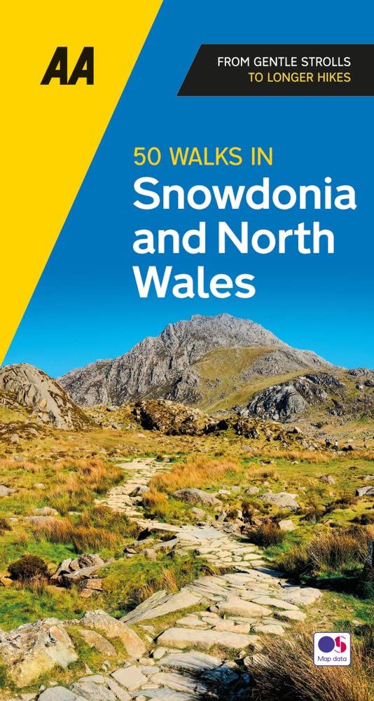
- Snowdonia & North Wales: AA 50 Walks
- Walking is one of Britain`s favourite leisure activities, and AA 50 Walks in Snowdonia & North Wales features a variety of mapped walks of two to ten miles, to suit all abilities. The book features all the practical detail you need, accompanied by fascinating background reading on the history and wildlife in Snowdonia & North Wales, and clear... Read more

Stanfords
United Kingdom
United Kingdom
- DK Eyewitness Great Britain
- Discover Great Britain - a beautiful land rich in culture and history. Whether you want to go wild swimming in the Fairy Pools of Skye, take a windswept walk along the Jurassic Coast, or scale the heights of Snowdonia, your DK Eyewitness travel guide makes sure you experience all that Great Britain has to offer.From the jagged peaks of the... Read more

Stanfords
United Kingdom
United Kingdom
- Wild Pub Walks
- Join the author on 30 walks in beautiful remote or mountain landscapes, each with a great pub - often with historical significance - at journey`s end. The book is aimed at the large market of hill walkers who enjoy long days out followed by a great pint in a great pub.The areas covered are: Peak District; Lake District; Highlands/Islands;... Read more


Stanfords
United Kingdom
2021
United Kingdom
2021
- DK Eyewitness Road Trips Great Britain
- With its idyllic market towns, romantic castle ruins and stunning natural landscapes, Great Britain is the perfect destination for a leisurely road trip. It`s yours to explore with Road Trips Great Britain, which contains 25 drives across the country, from the sweeping sandy beaches of Cornwall to the dramatic peaks of the Scottish... Read more

Stanfords
United Kingdom
United Kingdom
- Aberystwyth & Machynlleth OS Landranger Active Map 135 (waterproof)
- Central Wales around Aberystwyth and Machynlleth, including the southernmost part of the Snowdonia National Park and a section of the Glyndwr’s Way Long-distance Path, on a waterproof and tear-resistant OS Active version of map No. 135 from the Ordnance Survey’s Landranger series at 1:50,000, with contoured and GPS compatible topographic... Read more

Stanfords
United Kingdom
United Kingdom
- Cadair Idris & Bala Lake OS Explorer Active Map OL23 (waterproof)
- Cadair Idris and Llyn Tegid area of the Snowdonia National Park on a detailed topographic and GPS compatible map OL23, waterproof version, from the Ordnance Survey’s 1:25,000 Explorer series. Coverage extends from Bala in the north-east to the coast between Barmouth and Ynyslas, and includes Dolgellau, Tywin, Machynlleth, the epaks of Moel... Read more


Stanfords
United Kingdom
2019
United Kingdom
2019
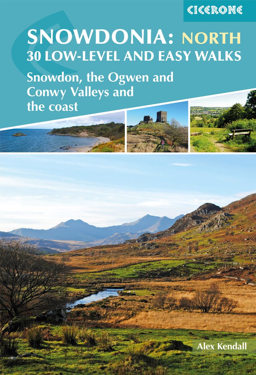
- Snowdonia: Low-level and easy walks - North: Snowdon, the Ogwen and Conwy Valleys and the coast
- This guidebook describes 30 low level and easy walks that are suitable for all abilities. The hikes covered are in the northern part of Snowdonia National Park, close to Conwy, Betws-y-Coed, Llanberis and Porthmadog. Most of the walks take around two hours, with others ranging from two to six hours.Each walk has an accompanying Ordnance Survey... Read more
- Also available from:
- The Book Depository, United Kingdom
- De Zwerver, Netherlands

The Book Depository
United Kingdom
2019
United Kingdom
2019
- Snowdonia: 30 Low-level and Easy Walks - North
- Snowdon, the Ogwen and Conwy Valleys and the coast Read more
De Zwerver
Netherlands
2019
Netherlands
2019
- Wandelgids Snowdonia: North - Low-level and easy walks | Cicerone
- Guidebook describing 30 walks in Snowdonia, Wales. Routes are mostly low level and on clear paths and showcase the region's beautiful scenery and rich history and culture. Part of a 2-volume set, this northern volume includes the Snowdon area, the Ogwen and Conwy Valleys, Betws-y-Coed, Beddgelert, Ffestiniog and the coast. Read more

Stanfords
United Kingdom
2019
United Kingdom
2019
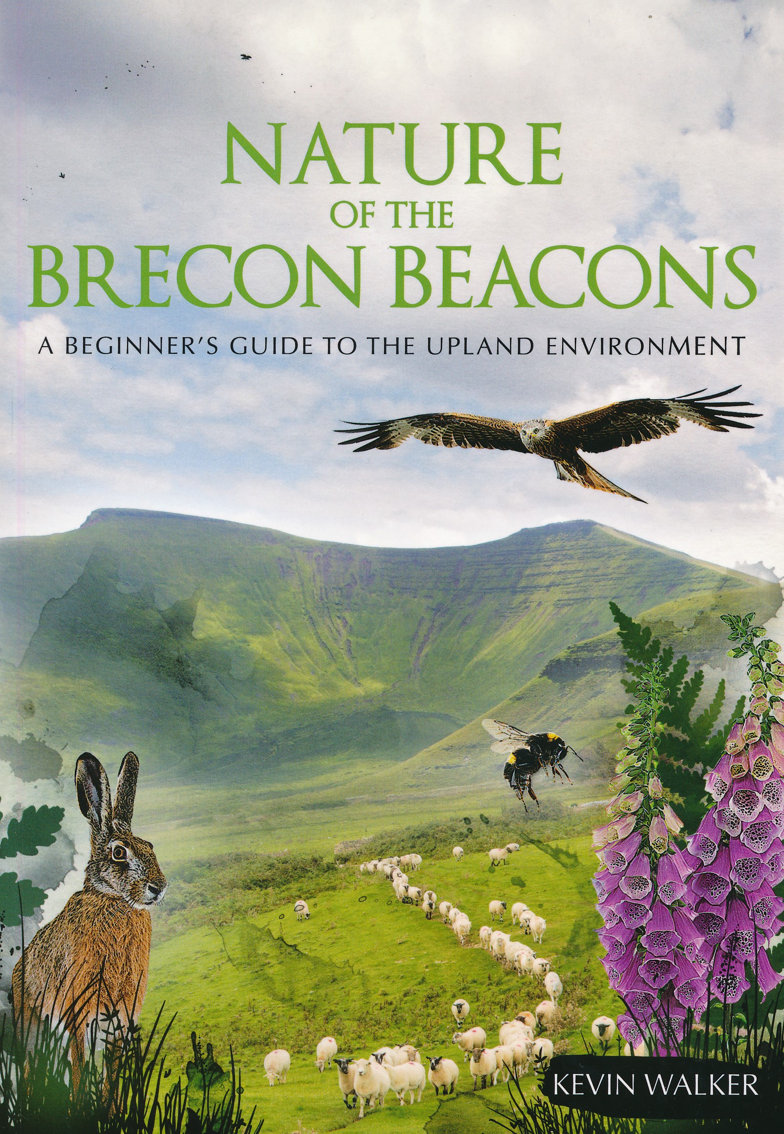
- Nature of the Brecon Beacons: A Beginners Guide to the Upland Environment
- For most people wandering through the beautiful landscape of the Brecon Beacons is pleasure enough, but sooner or later you may ask yourself, what is that little bird or flower that you see on most of your walks?The problem with most guides is that many of the animals, insects, rocks or plants in them are rarities, and therefore probably not... Read more
- Also available from:
- The Book Depository, United Kingdom
- De Zwerver, Netherlands

The Book Depository
United Kingdom
2019
United Kingdom
2019
- Nature of the Brecon Beacons
- A Beginners Guide to the Upland Environment Read more
De Zwerver
Netherlands
2019
Netherlands
2019
- Natuurgids Nature of the Brecon Beacons | Pesda Press
- A Beginners Guide to the Upland Environment Read more


- Also available from:
- De Zwerver, Netherlands

The Book Depository
United Kingdom
United Kingdom
Maps

Stanfords
United Kingdom
United Kingdom
- Porthmadog and Dolgellau 1902-1903
- Map No. 124, Porthmadog and Dolgellau 1902-1903, in the Cassini Historical Series of old Ordnance Survey mapping of England and Wales at 1:50,000 in a format designed to offer a convenient comparison with the present day coverage from the OS, and most locations in three different editions. Old historical maps have been combined so that the... Read more
Stanfords
United Kingdom
United Kingdom
- Denbigh and Colwyn Bay / Dinbych a Bae Colwyn 1902-1903
- Map No. 116, Denbigh and Colwyn Bay / Dinbych a Bae Colwyn 1902-1903, in the Cassini Historical Series of old Ordnance Survey mapping of England and Wales at 1:50,000 in a format designed to offer a convenient comparison with the present day coverage from the OS, and most locations in three different editions. Old historical maps have been... Read more
Stanfords
United Kingdom
United Kingdom
- Snowdon / Yr Wyddfa 1840-1841
- Map No. 115, Snowdon / Yr Wyddfa 1840-1841, in the Cassini Historical Series of old Ordnance Survey mapping of England and Wales at 1:50,000 in a format designed to offer a convenient comparison with the present day coverage from the OS, and most locations in three different editions. Old historical maps have been combined so that the sheet... Read more
Stanfords
United Kingdom
United Kingdom
- Bala and Lake Vyrnwy / Y Bala a Llyn Efyrnwy 1902-1903
- Map No. 125, Bala and Lake Vyrnwy / Y Bala a Llyn Efyrnwy 1902-1903, in the Cassini Historical Series of old Ordnance Survey mapping of England and Wales at 1:50,000 in a format designed to offer a convenient comparison with the present day coverage from the OS, and most locations in three different editions. Old historical maps have been... Read more
Stanfords
United Kingdom
United Kingdom
- Aberystwyth and Machynlleth 1901-1903
- Map No. 135, Aberystwyth and Machynlleth 1901-1903, in the Cassini Historical Series of old Ordnance Survey mapping of England and Wales at 1:50,000 in a format designed to offer a convenient comparison with the present day coverage from the OS, and most locations in three different editions. Old historical maps have been combined so that the... Read more
Stanfords
United Kingdom
United Kingdom
- Porthmadog and Dolgellau 1836-1841
- Map No. 124, Porthmadog and Dolgellau 1836-1841, in the Cassini Historical Series of old Ordnance Survey mapping of England and Wales at 1:50,000 in a format designed to offer a convenient comparison with the present day coverage from the OS, and most locations in three different editions. Old historical maps have been combined so that the... Read more
Stanfords
United Kingdom
United Kingdom
- Snowdon / Yr Wyddfa 1840-1922 (3-map set)
- Map No. 115, Snowdon / Yr Wyddfa 1840-1922 (3-map set), in the Cassini Historical Series of old Ordnance Survey mapping of England and Wales at 1:50,000 in a format designed to offer a convenient comparison with the present day coverage from the OS, and most locations in three different editions. Old historical maps have been combined so that... Read more
Stanfords
United Kingdom
United Kingdom
- Denbigh and Colwyn Bay / Dinbych a Bae Colwyn 1838-1924 (3-map set)
- Map No. 116, Denbigh and Colwyn Bay / Dinbych a Bae Colwyn 1838-1924 (3-map set), in the Cassini Historical Series of old Ordnance Survey mapping of England and Wales at 1:50,000 in a format designed to offer a convenient comparison with the present day coverage from the OS, and most locations in three different editions. Old historical maps... Read more
Stanfords
United Kingdom
United Kingdom
- Bala and Lake Vyrnwy / Y Bala a Llyn Efyrnwy 1836-1840
- Map No. 125, Bala and Lake Vyrnwy / Y Bala a Llyn Efyrnwy 1836-1840, in the Cassini Historical Series of old Ordnance Survey mapping of England and Wales at 1:50,000 in a format designed to offer a convenient comparison with the present day coverage from the OS, and most locations in three different editions. Old historical maps have been... Read more
Stanfords
United Kingdom
United Kingdom
- Porthmadog and Dolgellau 1836-1922 (3-map set)
- Map No. 124, Porthmadog and Dolgellau 1836-1922 (3-map set), in the Cassini Historical Series of old Ordnance Survey mapping of England and Wales at 1:50,000 in a format designed to offer a convenient comparison with the present day coverage from the OS, and most locations in three different editions. Old historical maps have been combined so... Read more
Stanfords
United Kingdom
United Kingdom
- Aberystwyth and Machynlleth 1833-1923 (3-map set)
- Map No. 135, Aberystwyth and Machynlleth 1833-1923 (3-map set), in the Cassini Historical Series of old Ordnance Survey mapping of England and Wales at 1:50,000 in a format designed to offer a convenient comparison with the present day coverage from the OS, and most locations in three different editions. Old historical maps have been combined... Read more
Stanfords
United Kingdom
United Kingdom
- Snowdon / Yr Wyddfa 1922
- Map No. 115, Snowdon / Yr Wyddfa 1922, in the Cassini Historical Series of old Ordnance Survey mapping of England and Wales at 1:50,000 in a format designed to offer a convenient comparison with the present day coverage from the OS, and most locations in three different editions. Old historical maps have been combined so that the sheet lines... Read more
Stanfords
United Kingdom
United Kingdom
- Bala and Lake Vyrnwy / Y Bala a Llyn Efyrnwy 1836-1922 (3-map set)
- Map No. 125, Bala and Lake Vyrnwy / Y Bala a Llyn Efyrnwy 1836-1922 (3-map set), in the Cassini Historical Series of old Ordnance Survey mapping of England and Wales at 1:50,000 in a format designed to offer a convenient comparison with the present day coverage from the OS, and most locations in three different editions. Old historical maps... Read more
Stanfords
United Kingdom
United Kingdom
- Denbigh and Colwyn Bay / Dinbych a Bae Colwyn 1838-1841
- Map No. 116, Denbigh and Colwyn Bay / Dinbych a Bae Colwyn 1838-1841, in the Cassini Historical Series of old Ordnance Survey mapping of England and Wales at 1:50,000 in a format designed to offer a convenient comparison with the present day coverage from the OS, and most locations in three different editions. Old historical maps have been... Read more
Stanfords
United Kingdom
United Kingdom
- Porthmadog and Dolgellau 1921-1922
- Map No. 124, Porthmadog and Dolgellau 1921-1922, in the Cassini Historical Series of old Ordnance Survey mapping of England and Wales at 1:50,000 in a format designed to offer a convenient comparison with the present day coverage from the OS, and most locations in three different editions. Old historical maps have been combined so that the... Read more